
London, a city renowned for its rich history, iconic landmarks, and vibrant cultural tapestry, offers an unparalleled experience for exploration on foot. Beyond its efficient underground network, the capital reveals its true character through its diverse streets, tranquil parks, and historic waterways. Walking provides an intimate perspective, allowing visitors and residents alike to discover hidden gems, absorb the architectural grandeur, and immerse themselves in the rhythm of this dynamic metropolis. From grand royal palaces to bustling markets and serene canals, London’s extensive network of pedestrian pathways caters to every interest and stamina level. This guide details eight of the most significant and rewarding walking routes, meticulously curated to showcase the city’s multifaceted appeal.
The London Landmark Route: A Journey Through Iconic Central London
The London Landmark Route, a comprehensive itinerary designed to encompass many of the city’s most recognizable sights, provides an intensive immersion into London’s historical and cultural core. While ambitious for a single day, it is strategically segmented to allow for leisurely exploration over several days.

Commencing in West London, the journey begins at Kensington Palace, a royal residence with a history spanning over 300 years, notably serving as the childhood home of Queen Victoria and more recently, the residence of Princess Diana. Visitors can explore the King’s and Queen’s State Apartments and various exhibitions. A short, picturesque stroll through Hyde Park, one of London’s largest Royal Parks, leads to the magnificent Albert Memorial, a Gothic Revival tribute to Prince Albert, and the adjacent Royal Albert Hall, a world-famous concert hall established in 1871, hosting a diverse array of performances and tours.
Continuing eastward, the route passes two of London’s most distinguished museums: the Natural History Museum and the Victoria and Albert Museum (V&A). The Natural History Museum, housed in a stunning Romanesque building, boasts a collection of over 80 million life and earth science specimens, including the renowned Hintze Hall skeleton. The V&A, the world’s leading museum of art, design, and performance, holds a permanent collection of over 2.8 million objects. Both institutions offer free admission, though a full day could easily be dedicated to each. From here, the path leads to Harrods in Knightsbridge, a globally recognized luxury department store founded in 1849, before reaching the Wellington Arch, a triumphal arch commemorating Wellington’s victories.

The subsequent section of the route connects the Wellington Arch to Buckingham Palace, the official residence and administrative headquarters of the monarch of the United Kingdom. During the summer opening, portions of the palace are accessible for tours, or visitors can observe the iconic Changing of the Guard ceremony. The walk then proceeds along The Mall to Trafalgar Square, a public square commemorating the Battle of Trafalgar, dominated by Nelson’s Column. Nearby, the National Portrait Gallery, established in 1856, houses a collection of portraits of historically important and famous British people, offering free entry.
The route then traverses lively entertainment districts, including Leicester Square and Chinatown, before arriving at Regent Street, a grand shopping thoroughfare known for its distinctive architecture. Further north, Oxford Street presents one of Europe’s busiest shopping streets. The journey then takes a significant detour to the British Museum, housing a vast collection of world art and artifacts, including the Rosetta Stone and the Elgin Marbles. This segment alone can occupy several hours or even a full day.

Returning south, the walk leads to the charming district of Covent Garden, famous for its market, street performers, and the Royal Opera House. From Covent Garden, the path circles back past Trafalgar Square to Whitehall, the heart of the British government, where visitors can glimpse Horse Guards Parade and Downing Street, the official residence of the Prime Minister. The route culminates at the magnificent Houses of Parliament and the iconic Big Ben, the clock tower housing the Great Bell.
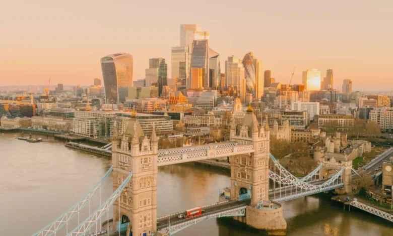
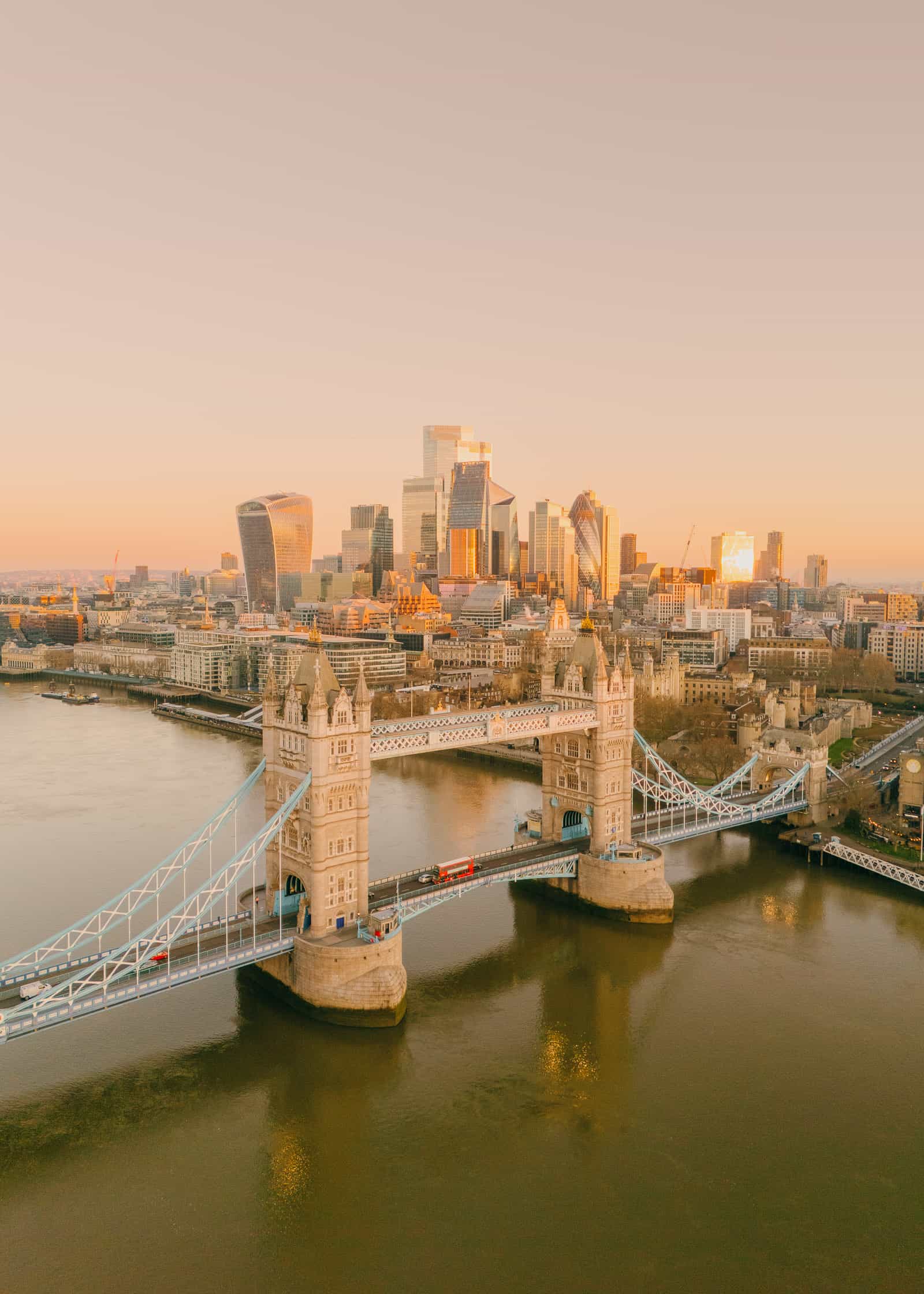
Crossing the River Thames via Westminster Bridge, the Southbank unfolds, offering views of the London Eye, a prominent cantilevered observation wheel. The path continues along the river to the Tate Modern, a contemporary art gallery housed in a former power station, and then to Shakespeare’s Globe, a faithful reconstruction of the Elizabethan playhouse. Finally, the route concludes at Borough Market, one of London’s largest and oldest food markets, and the historic complex of Tower Bridge and the Tower of London, a UNESCO World Heritage Site with a millennium of history, safeguarding the Crown Jewels.

Given its extensive nature, covering approximately 15-20 miles and numerous significant attractions, this route is best undertaken in sections over multiple days. Utilizing London’s efficient public transport (Tube or bus) between specific landmarks can optimize the experience for those with limited time. A free Google Maps list is available to guide walkers through each key point.
Regent’s Canal Walk: A Serene Urban Waterway Experience

Offering a tranquil escape from the urban hustle, the Regent’s Canal Walk provides a diverse journey through London’s lesser-known, greener facets. This 8.6-mile (13.8 km) linear route, typically requiring 3-4 hours of walking, traces the historic Regent’s Canal from King’s Cross to Little Venice.
The walk often begins or ends at Granary Square behind King’s Cross Station, an area revitalized with a vibrant array of restaurants, shops, and public art installations, offering an ideal spot for refreshment before or after the journey. The Regent’s Canal, constructed between 1812 and 1820, played a crucial role in transporting goods across London during the Industrial Revolution, connecting the Grand Junction Canal (now the Grand Union Canal) with the River Thames at Limehouse. Today, it serves as a picturesque leisure route.

Following the canal west, the path leads to Camden Town, a vibrant and eclectic district celebrated for its famous Camden Market, alternative fashion, and thriving music scene. The market, a labyrinth of stalls, offers everything from vintage clothing to international street food, providing a lively stopover.
Continuing along the towpath, walkers pass London Zoo, located within Regent’s Park. While the zoo itself requires admission, glimpses of some enclosures and the general ambiance can be enjoyed from the canal path. Adjacent to the zoo is Regent’s Park, one of London’s magnificent Royal Parks, boasting beautiful gardens, open spaces, and the Open Air Theatre.

The final stretch of the walk meanders through leafy residential areas, characterized by charming houseboats and elegant mansions, eventually arriving at Little Venice. This picturesque canal basin, where the Regent’s Canal meets the Grand Union Canal, is famed for its tree-lined waterways, waterside cafes (such as Cafe Laville), and charming boat community. It offers a serene conclusion to the journey, perfect for a relaxing meal or a quiet moment by the water. Like the Landmark Route, this walk can be segmented to suit individual preferences, with various Tube stations providing access points along the canal. A free Google Maps list aids navigation along this scenic route.
Central London Circular Walk: An Concentrated Tour of Downtown Highlights

For those seeking a comprehensive exploration of Central London’s key sites, the Central London Circular Walk offers an adaptable route that can be joined at any point. While extensive, spanning approximately 10-12 miles, it is best experienced in manageable sections, allowing for deeper engagement with each location.
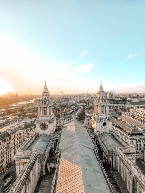
A suggested starting point is St Paul’s Cathedral, Sir Christopher Wren’s masterpiece, famous for its iconic dome and its survival of the Blitz. From here, the route heads east into the financial district, passing the Bank of England and the historic Royal Exchange, a former trading centre now housing luxury shops and restaurants. A short walk leads to Leadenhall Market, a stunning Victorian covered market known for its ornate architecture and as a filming location for Harry Potter.

Continuing to explore London’s modern skyline, the walk proceeds to the Sky Garden, located at the top of 20 Fenchurch Street (the "Walkie-Talkie" building). This offers one of London’s best free viewpoints, providing panoramic vistas across the city (advance booking of free tickets is essential). The path then leads to the Tower of London, a historic castle guarding the Crown Jewels and infamous for its past as a prison and execution site.
Crossing the River Thames via Tower Bridge, an engineering marvel from the Victorian era, the route arrives at Borough Market, a culinary hotspot offering gourmet food, fresh produce, and street food vendors. The Southbank continues to impress with Shakespeare’s Globe, a modern reconstruction of the original Globe Theatre, where visitors can take a tour or even catch a performance. Further along, the Tate Modern, housed in the former Bankside Power Station, showcases an impressive collection of international modern and contemporary art, with free entry to its permanent collection.

The route then crosses Westminster Bridge, passing the London Eye to reach the Houses of Parliament and Big Ben. A short walk leads to Westminster Abbey, a UNESCO World Heritage Site, a place of royal coronations, weddings, and burials since 1066. The path continues past Downing Street before entering St James’s Park, one of London’s most beautiful Royal Parks, offering stunning views of Buckingham Palace.
The walk culminates at Buckingham Palace, followed by a journey to the Wellington Arch. Turning east, the route passes the iconic Ritz Hotel, a symbol of luxury and tradition, famous for its afternoon tea. The path then sweeps through Piccadilly Circus, known for its vibrant electronic billboards, and into Chinatown, a bustling cultural enclave. Finally, the route circles back to Covent Garden and along The Strand, returning to St Paul’s Cathedral. This circular route provides a rich and varied experience of Central London, with a free Google Maps list available for easy navigation.

The Thames Path: Tracing London’s Lifeline
The Thames Path, a National Trail, is an extraordinary long-distance footpath stretching 185 miles (298 km) from the source of the River Thames in the Cotswolds to the Thames Barrier in East London. While the entire path is a multi-day undertaking, various sections within London offer superb walking experiences.
A particularly popular segment is the stretch from Greenwich eastward or westward. Greenwich, a UNESCO World Heritage Site, is rich in maritime history and offers numerous attractions: the Royal Naval College, home to the magnificent Painted Hall; the historic clipper ship Cutty Sark; the Royal Observatory, where the Prime Meridian (0° longitude) is located; and Greenwich Park, offering panoramic views and deer enclosures.
Walking westward from Greenwich along the Thames Path provides views of Canary Wharf and passes through historic riverside communities. This section eventually leads to central London landmarks such as Tower Bridge, Borough Market, the Tate Modern, and the London Eye, mirroring parts of the previously described routes. Further west, the path extends to areas like Battersea Power Station, a redeveloped industrial landmark now housing shops, restaurants, and apartments.

The historical significance of the Thames cannot be overstated; it has been London’s lifeblood for millennia, shaping its trade, defense, and development. Along the path, walkers encounter a blend of ancient riverside pubs, modern developments, and remnants of London’s industrial past. For instance, the Mayflower Pub in Rotherhithe is notable as the departure point for the Pilgrim Fathers’ ship. The entire segment from Greenwich to Battersea Power Station is a substantial walk, estimated to take around 8 hours at a casual pace, highlighting the need for segmenting the journey. Detailed maps and information for the Thames Path are available on the National Trails website.
The Line Art Walk: An Outdoor Gallery in East London
The Line Art Walk provides a unique cultural experience, showcasing a series of contemporary art installations along a linear route through East London. This accessible 3-mile (5 km) walk connects Queen Elizabeth Olympic Park to Greenwich Peninsula, making it ideal for art enthusiasts and those looking to explore a different side of London.
The walk begins in Stratford, East London, within the Queen Elizabeth Olympic Park, a legacy of the 2012 Olympic Games. Here, visitors can encounter the striking ArcelorMittal Orbit, a sculpture and observation tower that also features the world’s longest tunnel slide. The route then guides walkers past a curated selection of artworks. These include installations like "The Hatchling," "Liberty Grip," and "A Bullet from a Shooting Star," each offering a distinct artistic perspective and engaging with the urban landscape.

The Line is London’s first dedicated public art walk, established in 2015, demonstrating a commitment to integrating art into public spaces and making it accessible to all. The installations are strategically placed to highlight the industrial heritage and natural beauty of the waterways and landscapes of East London. The walk encourages a slower pace of exploration, inviting contemplation of the art in its specific environment. It offers an excellent opportunity to experience the transformation of East London, moving from Olympic regeneration zones to riverside areas around the O2 Arena in North Greenwich. A free PDF map detailing the route and art installations is available on The Line’s official website, providing essential guidance for this engaging urban art trail.
Capital Ring Walk: London’s Green Periphery

The Capital Ring Walk is an ambitious 78-mile (126 km) circular walking route that encircles Inner and Outer London, offering a profound contrast to the bustling central districts. Maintained by Transport for London (TfL), it is segmented into 15 manageable sections, each typically taking 3-4 hours to complete, making it ideal for day trips or a multi-week endeavor.
Unlike the central routes focused on iconic landmarks, the Capital Ring delves into London’s diverse suburbs and extensive green spaces, revealing a different character of the city. It showcases London’s surprising abundance of parks, woodlands, nature reserves, and historical villages that have been absorbed into the urban fabric.

Notable sections of the Capital Ring pass through areas such as the Olympic Park in the east, providing further opportunities to explore the legacy of the 2012 games. The route also takes in the impressive Thames Barrier, a movable flood defense protecting London from tidal surges. Further segments reveal historical sites like Eltham Palace, picturesque sections of the River Lea, and scenic viewpoints from places like Crystal Palace, site of the famous 1851 Great Exhibition. In the west, it incorporates parts of the London Loop and passes through areas known for their natural beauty and wildlife, such as Richmond Park with its deer herds.
The Capital Ring is meticulously signposted, and TfL provides downloadable maps and detailed guides for each section, including information on public transport links, making it highly accessible. This walk appeals to those seeking to experience London’s natural environment, its diverse communities, and its lesser-known historical narratives, far removed from the typical tourist trails.

Green Link Walk: Connecting Urban Green Spaces
The Green Link Walk is a continuous walking route designed to connect significant green spaces and parks across London, stretching from Epping Forest in the northeast to Peckham in South London. This route emphasizes the capital’s commitment to urban biodiversity and accessible green infrastructure, allowing walkers to experience London’s natural beauty interspersed with its urban environment.

The path traverses a variety of landscapes, from ancient woodlands to regenerated urban parks and historic common lands. Starting in Epping Forest, a vast ancient woodland on the London-Essex border, known for its diverse wildlife and historical significance, the route gradually moves towards more urban green spaces. It passes through areas like London Fields in Hackney, a popular urban park, and continues southward, intersecting with Central London.
Key points along the route include views of St Paul’s Cathedral and the Tate Modern, offering a blend of natural and cultural highlights. As it crosses the Thames into South London, the walk explores areas such as Burgess Park in Southwark, one of London’s largest parks created from an area of wartime devastation, and culminates in Peckham, a vibrant district known for its burgeoning arts scene, independent businesses, and panoramic rooftop views.

The Green Link is particularly appealing for those interested in sustainable urban living and exploring London’s commitment to green initiatives. It offers a contrasting perspective to the landmark-heavy routes, focusing instead on the city’s ecological corridors and community spaces. While the entire route is extensive, it is designed to be easily broken into segments, each providing a unique insight into London’s diverse character. Detailed maps and route information are available from Footways.London, enabling walkers to plan their journey through this verdant network.
Jubilee Walkway: A Royal and Historical Circuit

The Jubilee Walkway is a 15-mile (24 km) loop designed to celebrate the Silver Jubilee of Queen Elizabeth II in 1977, offering a concentrated tour of London’s royal and historical landmarks. This well-marked route provides an excellent framework for experiencing many of Central London’s most significant sites, ideally explored over 2-3 days to allow for comprehensive visits to attractions.
The walkway is divided into five distinct sections, each focusing on a particular aspect of London’s heritage: The Western Loop, The Strand Loop, The City Loop, The Jubilee Loop, and The Eastern Loop. It seamlessly integrates historical narratives with contemporary urban life.

Beginning at Trafalgar Square, the route immediately plunges into royal territory, leading to Buckingham Palace and through St James’s Park. It continues to Westminster Abbey, the Houses of Parliament, and Big Ben, emphasizing the seat of British power. Along the Thames, the path offers views of the London Eye and cultural institutions on the Southbank, including the Tate Modern and Shakespeare’s Globe.
The eastern sections of the walkway venture into the historic City of London, encompassing St Paul’s Cathedral, the Tower of London, and Tower Bridge. This segment highlights London’s ancient origins, its financial heart, and its enduring royal connections. The pathway’s design ensures that walkers encounter a continuous narrative of London’s past and present, from Roman origins to the modern era.

The Jubilee Walkway is distinguished by its unique pavement markers, embedded discs featuring the Queen’s crown, making it easy to follow. TfL provides comprehensive maps and guides for the entire route and its segments, along with information on nearby public transport connections. This walk is particularly recommended for tourists keen on understanding the royal lineage and historical milestones that have shaped London into the global city it is today, offering a structured yet flexible way to explore the capital’s grandeur and heritage.


