
The Ancient Waters of Wellness: Exploring the Arab World’s Most Revitalizing Hot Springs
For centuries, travellers have been drawn to the Arab world’s hidden network of natural wonders, a tapestry woven from the lush palm groves of Oman to the stark, mineral-rich landscapes of Saudi Arabia. Among the region’s most sought-after havens are its mineral-rich hot springs, rejuvenating fountains that appear to breathe new life into the surrounding terrains. These geothermal spas, often accessible through increasingly affordable luxury flights, offer an unparalleled opportunity for rest and renewal for those seeking respite from the relentless pace of modern life. This exploration delves into some of the most exceptional hot springs across the Arab world, highlighting their historical significance, therapeutic properties, and the unique experiences they offer.
The deep-seated value placed on hot mineral springs for their healing properties is a tradition deeply embedded within the cultures of the Middle East. Ancient societies recognized and congregated at these natural springs, immersing themselves in the mineral-rich waters to alleviate ailments and restore vitality. This cherished custom continues today, as adventurous travelers flock to the region’s renowned thermal oases, seeking the same restorative benefits that have been revered for millennia.
The Timeless Allure of Thermal Waters: Historical and Cultural Significance
The therapeutic properties of mineral-rich waters have been recognized and utilized across civilizations for thousands of years. Archaeological evidence suggests that ancient Greeks and Romans built elaborate bathhouses around natural hot springs, viewing them as sacred sites and centers for healing and social gathering. In the Arab world, the tradition is equally profound. Historical texts and oral traditions speak of nomadic tribes and settled communities alike seeking out these natural springs for their ability to soothe aches, heal wounds, and promote overall well-being.
The geological formations that give rise to these hot springs are a testament to the earth’s dynamic processes. Volcanic activity, tectonic shifts, and the slow percolation of water through mineral-laden rock strata contribute to the unique chemical compositions of these waters. Each spring, therefore, possesses a distinct mineral profile, offering a range of potential therapeutic benefits. The consistent temperatures, often naturally maintained by geothermal heat, provide a soothing and enveloping experience that is both physically relaxing and mentally calming.
Spotlight on Nine of the Arab World’s Premier Hot Springs
Ras Al Khaimah’s Khatt Hot Springs, United Arab Emirates
Nestled within the scenic emirate of Ras Al Khaimah, the Khatt Hot Springs present a captivating natural spectacle. These triple hot springs emerge from a limestone substrate, with their waters consistently flowing at a balmy 104°F (40°C). The spring waters are particularly rich in sulphur and other therapeutic minerals, earning them a reputation for their curative powers. Recognizing the potential of this natural asset, a luxury hotel and spa have been thoughtfully developed at the site. This integration allows guests to immerse themselves in the revitalizing mineral pools while being enveloped by tranquil gardens and sophisticated, first-class amenities. The presence of a modern wellness facility alongside the natural springs offers a seamless blend of ancient healing traditions and contemporary comfort, making it a premier destination for relaxation and rejuvenation in the UAE.
Moulay Yacoub Hot Springs, Morocco
Morocco, a land renowned for its exotic landscapes, is further enriched by its abundance of over 100 thermal springs. Among these, the Moulay Yacoub springs stand out as a particularly prized destination. Located a mere 12 miles from the ancient imperial city of Fez, these springs are celebrated for their waters, which are exceptionally rich in sulphur, mineral salts, sodium, calcium, and magnesium. Scientific analysis of the water composition has often pointed to its efficacy in alleviating a range of ailments, including rheumatoid conditions, ear, nose, and throat (ENT) issues, and chronic pain. The Moulay Yacoub Springs offer a profoundly rejuvenating escape, set amidst the mesmerizing and historic terrain of Morocco. The surrounding area offers a glimpse into traditional Moroccan life, further enhancing the immersive experience for visitors.
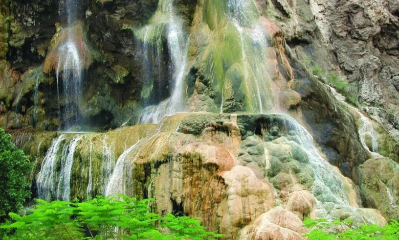
Ma’in Hot Springs, Jordan
Often lauded as one of the most attractive natural pools in the world, Jordan’s Ma’in Hot Springs are a true oasis in the heart of the Madaba region. Originating from basaltic mountain tops, the mineral-rich waters cascade through a series of natural waterfalls and pools, creating a breathtaking spectacle. Situated just an hour’s drive from the bustling capital city of Amman, Ma’in has become a magnet for wellness tourists. Visitors seek relief from skin conditions, circulatory issues, and joint and muscle pain, attributing their recovery to the unique mineral composition and therapeutic warmth of the springs. The idyllic setting, characterized by dramatic canyons and lush vegetation, combined with modern spa facilities, provides the perfect backdrop for both profound relaxation and holistic healing. The accessibility from Amman makes it a convenient yet transformative getaway.
Siwa Oasis Hot Springs, Egypt
Within the remote and ancient Siwa Oasis in Egypt, natural hot springs have served as therapeutic sanctuaries since antiquity. The most celebrated among these is Cleopatra Spring, a natural stone pool perpetually replenished by a pure, natural spring. This timeless oasis holds a rich historical legacy, having been frequented by ancient Egyptian, Persian, and Bedouin civilizations who sought the restorative benefits of its mineral-infused waters. Today, visitors can immerse themselves in the same revitalizing springs that were reputedly favored by Cleopatra herself. The journey to Siwa is an adventure in itself, often involving travel through desert landscapes, culminating in the serene and verdant embrace of the oasis, making the experience of its hot springs all the more rewarding.
Ad-Dal’a Hot Springs, Saudi Arabia
Approximately an hour’s drive from Riyadh, in the Saudi town of Al-Kharj, lies the astonishing Ad-Dal’a hot spring. This natural marvel is distinguished by its remarkable depth, plunging to an astounding 98 feet (30 meters). Ad-Dal’a is intricately connected by an underground channel to the nearby Samha Spring, located just 49 feet (15 meters) away. The interplay between these two springs, their mysterious depths, and the eternal charm and natural beauty of their surroundings create an experience steeped in wonder and profound relaxation. For travelers exploring Saudi Arabia, Ad-Dal’a offers a unique blend of natural spectacle and tranquil respite, a testament to the country’s diverse geological offerings.
Korbous Hot Springs, Tunisia
The quaint village of Korbous, situated about an hour’s drive from Tunis, offers a serene hot spring getaway featuring seven restorative mineral pools. The temperatures of these springs are notably high, ranging from 111°F to 140°F (44-60°C). Local lore and anecdotal evidence suggest that these waters offer significant therapeutic advantages for a range of conditions, including arthritis and various respiratory ailments. Set amidst Tunisia’s breathtaking natural beauty, Korbous provides a tranquil setting for rest and renewal, surrounded by undulating hills and rich, verdant vegetation. The accessibility from the capital makes it an ideal day trip or short retreat for those seeking natural healing.
Nakhal Hot Springs, Oman
Ninety minutes from Muscat, the Nakhal Hot Springs, also known as Ain Al Thawarah, gush forth from the Silud Mountain, creating a picturesque and verdant oasis. The steaming waters flow for nearly 100 feet before gracefully splitting into two charming streams, all embraced by vibrant palm groves. This natural setting offers a visually stunning and tranquil environment for relaxation. Adding to the allure, visitors can explore the historic 17th-century Nakhal Fort, which stands majestically nearby. The combination of the restorative hot springs and the historical significance of the fort imbues the experience with a sense of timeless enchantment, making it a dual attraction for both wellness and cultural exploration.
Wadi Ad-Dawasir’s Al-Jubah Hot Springs, Saudi Arabia
Deep within the vast Wadi Ad-Dawasir valley in Saudi Arabia lies the Al-Jubah Hot Springs, a sanctuary renowned for its healing properties. The waters are naturally rich in sulphur, a mineral highly regarded for its efficacy in treating joint diseases and rheumatism. These curative waters are thoughtfully harnessed at modern pool facilities, designed to offer visitors the ultimate rejuvenating escape. After a restorative soak in the mineral-rich waters, guests are encouraged to continue their wellness journey by exploring the serene and expansive desert landscapes of the wadi. This integration of therapeutic bathing with the natural beauty of the desert provides a holistic experience for body and mind.
The Profound Rejuvenating Benefits of Thermal Springs
Soaking in thermal mineral springs offers a multitude of revitalizing advantages that extend beyond simple relaxation. The unique combinations of minerals present in the waters are believed to improve blood circulation, which can aid in the treatment of various ailments. Many visitors report relief from respiratory discomfort, skin conditions, and persistent muscle aches and arthritis. The therapeutic warmth of the water aids the body in remineralization, a process that can help replenish essential minerals lost through daily life or illness.
Furthermore, thermal springs are potent agents of detoxification. The heat and mineral content can stimulate the body’s natural processes for eliminating toxins, promoting a sense of internal cleansing. Perhaps most significantly, however, thermal springs offer profound stress reduction. As the warm waters dissolve physical tension, they simultaneously encourage mental stillness. Unwinding in these breathtaking natural environments allows for a calming, introspective experience, leading to a state of deep peace and mental clarity. The cumulative effect of these benefits leaves individuals feeling thoroughly cleansed, spiritually balanced, and physically restored, a testament to the restorative power of nature.
Navigating the Path to Wellness: Accessing the Arab World’s Finest Hot Springs
Thermal springs have been a timeless draw for travelers seeking relaxation, healing, and profound renewal. The Arab world, with its rich geological diversity and deep-rooted traditions of wellness, offers an abundance of natural mineral-rich fountains that provide the perfect settings to experience the age-old remedies of therapeutic bathing. From secluded oases that whisper tales of ancient civilizations to dramatic terraced pools carved by nature’s hand, each of these extraordinary hot springs offers its own unique sense of tranquility and escape.
The accessibility of these natural wonders is continually improving. Many regions are investing in infrastructure to better serve tourists, while airlines like Flyadeal are offering more affordable flight options, making these rejuvenating destinations within reach for a broader audience. Whether one seeks relief for physical ailments, a respite from mental fatigue, or a spiritual connection with the natural world, the Arab world’s finest geothermal retreats await. They offer an opportunity to immerse oneself in the restorative powers of nature’s precious waters, promising a journey of revival and rejuvenation for the soul. The enduring appeal of these natural wonders lies in their ability to connect us with the earth’s elemental forces, offering a profound and lasting sense of well-being.


