The Pakora Pass Trek from Naltar to Ishkoman Valley: A Comprehensive Guide to Northern Pakistan’s Premier High-Altitude Route

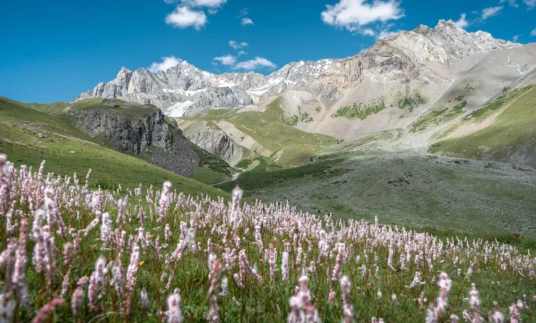
The Pakora Pass trek, historically known as the Naltar Pass, represents one of the most significant yet under-utilized high-altitude corridors in the Gilgit-Baltistan region of northern Pakistan. Connecting the lush, forested landscapes of the Naltar Valley with the rugged, culturally distinct Ishkoman Valley in the Ghizer District, the route serves as a testament to the diverse topography of the Karakoram and Hindu Kush mountain ranges. Unlike the heavily trafficked circuits toward K2 Basecamp or the Patundas Glacier, this three-day expedition offers a pristine wilderness experience that remains largely untouched by commercial tourism.
Geographical Context and Strategic Significance
The trail traverses an elevation range that begins in the alpine meadows of Naltar—renowned for its biodiversity and seven-colored lakes—and peaks at the formidable, snow-capped Pakora Pass. The region is part of the broader nexus of the Gilgit-Baltistan corridor, a zone of immense geological complexity where the collision of tectonic plates has created a dramatic landscape of glaciers, deep river valleys, and vertical cliffs.
For centuries, these paths were utilized by local pastoralists and shepherds to move livestock between summer and winter grazing grounds. The trail acts as a vital artery for the local economy, facilitating the movement of livestock and serving as a seasonal link between communities. While modern infrastructure has connected major urban centers like Gilgit, the Pakora Pass remains a traditional transit route, preserving the ancient rhythms of high-altitude life.
Chronology and Trekking Logistics
A standard traversal of the Pakora Pass involves a rigorous three-day itinerary. The trek typically commences at the terminal point of the Naltar Valley jeep road, near the Satrangi Lake.
Day 1: The Ascent to Lower Shani
The initial stage covers approximately 10 to 12 kilometers. Trekkers move from the Naltar zero point toward the Lower Shani area. Historically, paths were routed along the west side of the river; however, frequent glacial flooding and seismic shifts have rendered these routes unstable. Current navigational best practices, as reported by local mountain guides, suggest maintaining an eastern trajectory along the mountainside. This route provides safer passage through the alpine meadows, where shepherds congregate during the summer months.
Day 2: Navigating the Pakora Pass
The second day is characterized by high-altitude exertion and technical navigation. Hikers must choose between higher, more stable routes or lower, landslide-prone paths. The ascent to the pass requires traversing active glacial fields. Safety protocols in this region mandate caution, as glacial movement is dynamic and routes can shift annually. The summit of the pass offers panoramic views of Shani Peak and the distant, towering silhouette of Rakaposhi, provided atmospheric conditions remain clear.
Day 3: Descent through Pakora Nala
The final leg covers 17 to 22 kilometers, descending into the Pakora Nala. The terrain transitions from high-altitude rubble to dense, juniper-forested valleys. This section of the trek is notable for its narrow, cliff-hugging paths that prevent the use of pack animals, highlighting the isolation of the upper valley. The descent concludes in the village of Pakora, where the hospitality of the local Ishkoman community provides a stark contrast to the solitude of the high peaks.
Economic and Professional Perspectives
The growth of regional tourism has led to a structured, albeit informal, economy surrounding these mountain routes. Local guides from the Ishkoman Valley, such as Hakim, emphasize the importance of professional support for international trekkers.
The standard daily rate for a professional guide—who provides logistics, translation services, and emergency support—is approximately 12,000 PKR. For budget-conscious travelers, independent trekking remains a possibility, though it requires advanced proficiency in navigation and glacial safety. Local stakeholders note that hiring local guides does more than ensure safety; it facilitates direct economic investment into remote communities and fosters cultural exchange.
Data from local tourism boards suggests that while the number of trekkers on the Pakora Pass remains in the low hundreds annually, there is a steady year-over-year increase in interest. This influx has spurred the development of specialized accommodation, such as the Coyote Den in Chatorkhand, which serves as a vital base for post-trek recovery.
Safety Protocols and Environmental Stewardship
The remote nature of the Pakora Pass necessitates stringent safety planning. Key considerations include:
- Navigation: While routes are documented on platforms like Open Street Maps, the dynamic nature of the terrain—specifically regarding bridge integrity and landslide activity—makes reliance on real-time local intelligence essential.
- Acclimatization: The rapid change in elevation requires adequate acclimatization to prevent altitude-related illnesses.
- Environmental Impact: The region is ecologically fragile. Professional guidelines emphasize the "Leave No Trace" principle, particularly given the lack of formal waste management infrastructure at higher altitudes.
- Emergency Communication: The absence of consistent cellular coverage makes satellite-enabled communication devices or the presence of a local guide highly recommended.
Broader Impact and Regional Implications
The development of the Pakora Pass as a sustainable trekking destination aligns with the broader goals of the Gilgit-Baltistan government to diversify tourism offerings beyond the Karakoram Highway. By promoting lesser-known routes, the region aims to alleviate the environmental and social pressures placed on popular sites like Fairy Meadows or the Hushe Valley.
Furthermore, the integration of these remote valleys into the tourism circuit has profound implications for local infrastructure. Improved access to remote villages often leads to better health and educational outcomes for the residents. However, analysts warn that rapid, unregulated tourism could threaten the cultural integrity of these isolated communities. Consequently, there is an ongoing discussion regarding the implementation of managed trekking permits and community-led conservation initiatives to ensure that the influx of visitors remains sustainable.
Future Prospects for Northern Trekking
The vision of a "grand route"—connecting the Naltar, Ishkoman, Yasin, and Broghil valleys—represents the next frontier for trekking in Pakistan. Such a route would rival the world’s most renowned long-distance trails, offering a unique blend of high-altitude challenge and cultural immersion. The successful completion of the Pakora Pass trek is seen by many as the foundational step toward achieving this regional connectivity.
As the global trekking community continues to seek alternatives to overcrowded destinations in the Himalayas, the Pakora Pass stands out as a viable, rewarding, and authentic experience. The success of the route depends on the balance between facilitating accessibility and maintaining the wild, pristine character that makes the Gilgit-Baltistan region a premier destination for mountain enthusiasts worldwide. For those prepared for the physical demands and the necessity of self-sufficiency, the pass offers an unparalleled window into the heart of the Karakoram, a landscape defined by its silence, its scale, and its enduring, rugged beauty.