The Pakora Pass Trek: A Comprehensive Guide to Navigating the High-Altitude Corridor Between Naltar and Ishkoman Valley

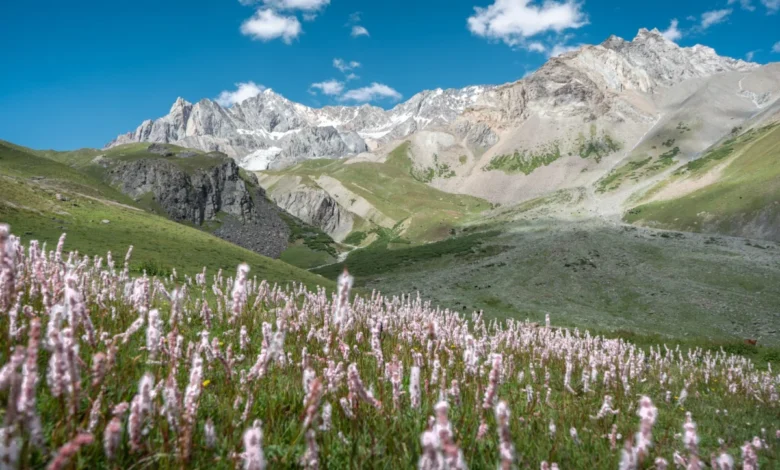
The Pakora Pass, frequently referred to by locals as the Naltar Pass, represents one of the most significant yet under-utilized high-altitude transit corridors in the Gilgit-Baltistan region of Pakistan. Connecting the verdant Naltar Valley with the rugged, culturally distinct Ishkoman Valley, the trek serves as a vital historical route for seasonal migration and livestock movement. While major trekking destinations like the K2 Basecamp and the Patundas Glacier draw thousands of international trekkers annually, the Pakora Pass remains a pristine, secluded alternative that offers deep insight into the nomadic traditions of the Karakoram and Hindu Kush mountain ranges.
Geological and Geographical Context
Situated within the broader ecosystem of the Gilgit-Baltistan territory, the Pakora Pass traverses terrain characterized by dramatic elevation gains, ranging from the lush, sub-alpine meadows of the Naltar Valley to the rocky, glaciated heights of the pass itself. The region is part of a complex mountain network where the Karakoram, Himalayas, and Hindu Kush ranges converge.
The physical geography of the pass is defined by active glacial systems and seasonal water runoff, which significantly influence the stability of established trails. Recent environmental assessments of the region indicate that climate-induced glacial recession and increased frequency of seasonal floods have altered traditional footpaths, necessitating careful navigation and reliance on updated topographical data, such as that provided by OpenStreetMap or offline GPS navigation tools like OSMand.
Historical and Cultural Significance
The route has historically functioned as a pathway for transhumance—the seasonal movement of livestock between lower valley winter pastures and high-altitude summer grazing grounds. For generations, the shepherds of Gilgit-Baltistan have utilized the Pakora Pass to access alpine pastures, fostering a unique culture of resilience and self-sufficiency.
Unlike the commercialized trekking circuits, the Pakora Pass corridor is characterized by the presence of traditional shepherd huts, or "shielings." These settlements are not tourism-oriented but serve as functional hubs for agricultural activities. Interactions with the local population are common but should be approached with cultural sensitivity, as the area is primarily a working environment for local pastoralists.
Chronology of the Three-Day Expedition
For those attempting the full traverse, the trek is typically structured as a three-day expedition, though physical fitness and acclimatization can extend the duration.
Day One: Naltar to Lower Shani (10–12 kilometers)
The journey begins in the Naltar Valley, near the Satrangi Lake. Trekkers must manage an initial ascent that moves away from the valley floor. Environmental factors, particularly the risk of riverbank erosion caused by glacial melt, have rendered some lower-altitude bridges unreliable. Local guidance suggests maintaining a path on the eastern side of the river to avoid potential washed-out sections of the trail. The day concludes in the Lower Shani area, a high-altitude meadow that serves as a base camp for the subsequent ascent.
Day Two: The Ascent to Pakora Pass (10–12 kilometers)
The second day is the most technical and physically demanding. The route requires crossing the pass and negotiating at least one significant glacier. Climbers must choose between high-altitude and low-altitude routes; while the former is often more stable, the latter is prone to landslides. Navigating the glacier requires caution, as surface conditions vary significantly depending on the time of year and weather patterns. Proper footwear and, in many cases, professional guidance are required to mitigate the risk of injury during these crossings.
Day Three: Descent through Pakora Nala (17–22 kilometers)
The final leg of the trek is a sharp, consistent descent through the Pakora Nala. This region is distinguished by dense juniper forests and narrow, winding paths that are often impassable for pack animals, emphasizing the rugged nature of the terrain. The trek terminates at Pakora Village in the Ishkoman Valley, a location celebrated for its hospitality and access to the regional infrastructure of the Ghizer District.
Economic and Logistical Framework
The logistics of trekking in the Gilgit-Baltistan region are increasingly managed through a combination of independent planning and local service providers.
- Trekking Personnel: While experienced mountaineers may navigate the route independently, hiring a local guide is strongly recommended for safety. As of August 2026, standard rates for a qualified English-speaking guide are approximately 12,000 PKR per day. For budget-conscious travelers, local shepherds may provide navigational assistance for a smaller fee, though language barriers and a lack of formal logistical training should be anticipated.
- Infrastructure: The Ishkoman Valley has seen improvements in traveler accommodation, with facilities like the Coyote Den in Chatorkhand providing necessary support for those finishing the trek. These establishments offer essential recovery services, including showers and medical support, which are critical following a multi-day high-altitude traverse.
- Safety Protocols: The lack of cell service and the volatility of the mountain environment mandate that all trekkers register their itinerary with local authorities or reputable guest houses. Carrying sufficient food supplies and portable cooking fuel is essential, as the high-altitude zones above the timberline lack natural fuel sources.
Broader Implications for Sustainable Tourism
The Pakora Pass represents a model for low-impact, sustainable adventure tourism. By distributing foot traffic away from the highly congested K2 and Baltoro regions, the route reduces the environmental burden on over-visited sites. However, this shift in traffic carries the responsibility of preserving the ecological integrity of the Naltar and Ishkoman corridors.
Local officials and conservationists have highlighted the importance of "leave-no-trace" principles in these remote areas. As the region gains popularity, the development of standardized waste management and sustainable trail maintenance will be crucial to preventing the degradation of alpine meadows. Furthermore, the integration of local communities into the tourism value chain—ensuring that revenue from trekking activities directly supports the pastoralists who maintain these paths—is considered a primary objective for regional development in Gilgit-Baltistan.
Conclusion: A Route for the Future
The Pakora Pass is a testament to the untapped potential of Pakistan’s high-altitude wilderness. It offers a rare opportunity to engage with the natural beauty of the Karakoram range in a manner that is both challenging and authentic. While the physical demands of the trek are significant, the combination of floral diversity, glacial landscapes, and the genuine hospitality of the Ishkoman Valley residents ensures that the route remains a premier destination for those seeking to move beyond the traditional tourism circuits. As infrastructure in the region continues to evolve, the Pakora Pass stands as a vital link between the preservation of ancient nomadic traditions and the modern pursuit of wilderness exploration.