The Pakora Pass Trek: Navigating the High-Altitude Corridor Connecting Naltar to Ishkoman Valley

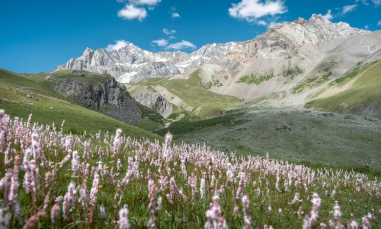
The Pakora Pass, also known as Naltar Pass, stands as a high-altitude gateway in the Gilgit-Baltistan region of northern Pakistan, linking the Naltar Valley to the Ishkoman Valley. For mountaineers and trekkers seeking to avoid the increasingly congested corridors of the Karakoram, this three-to-four-day route offers an alternative passage through some of the most pristine alpine environments in the Hindu Kush-Karakoram transition zone. Unlike the heavily trafficked routes toward K2 Basecamp, the Pakora Pass corridor remains a sanctuary for local shepherds and a challenge for those pursuing solitude and technical navigation through high-alpine terrain.
Geographical Significance and Context
The region of Gilgit-Baltistan is defined by the convergence of the world’s three highest mountain ranges: the Himalayas, the Karakoram, and the Hindu Kush. While major expeditions focus on the 8,000-meter peaks, the lateral valleys—specifically Naltar and Ishkoman—represent vital ecological zones. The Pakora Pass sits at a significant elevation, requiring trekkers to traverse glaciated sections and navigate variable weather patterns common to the high altitudes of the Ghizer District.
The trek is characterized by its dramatic shifts in landscape, moving from the lush, juniper-forested meadows of the Naltar side to the stark, rubble-strewn alpine terrain near the pass, and finally descending into the cultural hospitality of the Ishkoman Valley. The route serves not merely as a recreational path but as a historic, albeit seasonal, conduit for the transhumance of livestock, a practice that has sustained the local pastoral economy for generations.
Chronology of the Route
The traverse typically begins at the Naltar zero point, near Satrangi Lake. The first phase, lasting approximately 10 to 12 kilometers, involves a ascent through alpine meadows. Historically, the route followed a specific bridge network across the Naltar river; however, climate-induced glacial flooding and landslides have rendered several of these structures unreliable. Modern navigation now favors the east side of the river, which, while steeper, remains more structurally sound.
The second day represents the technical crux of the journey. Trekkers must navigate the ascent to the pass itself, which involves crossing active glaciers. The route is not marked by permanent trail infrastructure, requiring trekkers to rely on GPS waypoints or the local knowledge of indigenous guides. The pass offers panoramic views of Shani Peak and the distant massifs of the Rakaposhi range.
The third day consists of a rigorous descent through the Pakora Nala. This section is noted for its dense juniper forests and steep gradients. The final stretch terminates in the village of Pakora, where the local community maintains a long-standing tradition of hospitality toward those who complete the arduous trek.
Supporting Data and Logistics
For those planning the traverse, the logistical requirements are substantial. The absence of commercial tourism infrastructure necessitates complete self-sufficiency in terms of food, medical supplies, and shelter.
- Trek Duration: 3 to 4 days, depending on physical conditioning and weather conditions.
- Optimal Season: Late June through September. Outside of this window, high-altitude passes in Gilgit-Baltistan are subject to heavy snow accumulation and high risk of avalanche.
- Guide Services: While independent trekking is possible for those with advanced navigational skills, hiring a local guide is strongly recommended. Local guides in the Ishkoman region typically charge approximately 12,000 PKR per day. For budget-conscious travelers, shepherd-guided options may be available, though these usually lack the logistical support of professional mountaineering guides.
- Equipment: Due to the glacial nature of the pass, equipment for cold-weather survival and high-altitude navigation is mandatory. Reliance on mobile applications like OSMand for offline map tracking is standard practice, as cellular connectivity is nonexistent once the trek departs the valley floor.
Professional Perspectives and Safety
Local guides, such as Hakim of the Ishkoman Valley, emphasize that the primary danger on the Pakora Pass is not the altitude itself, but the unpredictability of glacial movement. "Glaciers in this region are in a constant state of flux," notes one regional trekking expert. "A path that is safe one season may be fractured by crevasses or blocked by rockfall the next. The decision to cross a glacier should always be made with the input of someone who understands the current state of the ice."
The physical demand of the route also presents a significant challenge. The descent from the pass involves a vertical drop of several thousand meters, which can lead to rapid onset of knee and ankle strain. Proper acclimatization in the Naltar Valley prior to the ascent is considered a best practice to mitigate the risks associated with Acute Mountain Sickness (AMS).
Economic and Cultural Implications
The increasing interest in the Pakora Pass is viewed as a double-edged sword by regional stakeholders. On one hand, it provides a supplementary income stream for local residents who act as guides, porters, and hosts in villages like Chatorkhand. On the other, it introduces the necessity of environmental management. The Pakora Nala is an ecologically sensitive area, and the lack of waste management infrastructure means that all waste must be carried out by the trekker to preserve the integrity of the alpine meadows.
The hospitality encountered in the Ishkoman Valley is a notable cultural feature. Unlike the more commercialized tourist hubs of northern Pakistan, the villages of Ishkoman maintain a traditional social structure where the arrival of a traveler is often met with community-based support. This interaction provides a rare glimpse into the life of the mountain communities of the Ghizer District, far removed from the international tourism circuit.
Broader Impact on Northern Pakistan Tourism
The shift toward "slow" and remote trekking in Gilgit-Baltistan is part of a broader trend in global adventure tourism. As traditional destinations reach saturation, remote corridors like the Pakora Pass become essential for the long-term sustainability of the regional economy. By dispersing the footprint of tourism across a wider geographical area, local authorities and community leaders hope to foster a more resilient and equitable economic model.
However, the expansion of such routes remains contingent on infrastructure development that does not compromise the natural environment. Future considerations include the potential for formalized trail markers and the establishment of base camps that provide minimal-impact shelter, potentially reducing the reliance on open-fire cooking, which can pose a wildfire risk to the sensitive juniper forests.
In conclusion, the Pakora Pass remains one of the most challenging and rewarding routes in Pakistan. It is a trek that demands respect for the environment, physical preparation, and an appreciation for the local culture. For the seasoned trekker, it offers a rare opportunity to engage with the high-altitude wilderness of the Karakoram in its most authentic state. As the region continues to open up, the preservation of these trails will remain a priority for those who value the balance between adventure and conservation.