The Pakora Pass Trek: A Comprehensive Guide to Navigating the Naltar to Ishkoman Wilderness

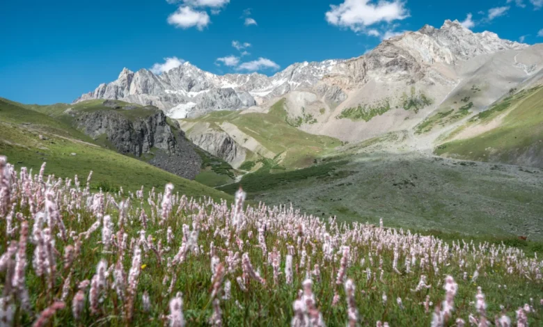
The Pakora Pass, also known as the Naltar Pass, stands as one of the most significant yet under-traversed high-altitude corridors in the Gilgit-Baltistan region of northern Pakistan. Connecting the lush, forested Naltar Valley with the rugged, culturally rich Ishkoman Valley, this three-to-four-day expedition offers a unique window into the geography of the Karakoram and Hindu Kush mountain ranges. Unlike the heavily commercialized basecamp treks that define the popular tourism circuit, the Pakora Pass route remains a sanctuary for local shepherds and a challenge for the intrepid hiker, characterized by alpine meadows, active glaciers, and a profound absence of modern infrastructure.
Geographical Context and Historical Significance
The Gilgit-Baltistan region serves as the intersection point for three of the world’s most formidable mountain systems: the Himalayas, the Karakoram, and the Hindu Kush. While international attention is frequently drawn to the K2 Basecamp or the expansive glaciers of the Baltoro region, the corridor between Naltar and Ishkoman represents a critical historical transit point for nomadic communities.
The Pakora Pass facilitates a traditional transhumance route—a seasonal migration pattern where shepherds move their livestock between lower elevation villages and high-altitude pastures. This migration has sustained the local economy for generations, fostering a culture of hospitality and self-reliance that remains largely untouched by the influx of international mountaineering expeditions seen elsewhere in the country.
Chronological Itinerary and Route Logistics
The traversal of the Pakora Pass is a logistical undertaking that requires careful planning, physical preparation, and an understanding of the region’s volatile mountain environment.
Phase One: Naltar to Lower Shani
The journey typically commences at the terminus of the Naltar Valley road, near the Satrangi Lake. Hikers progress through the lower alpine zone, where the terrain is dominated by dense forests and river-fed meadows. This section, spanning approximately 10 to 12 kilometers, serves as an acclimatization period. Travelers are advised to remain on the eastern side of the river, as seasonal flooding often compromises bridges and infrastructure on the western bank, rendering the eastern route more reliable and ecologically stable.
Phase Two: The Ascent to Pakora Pass
The second day represents the most physically demanding segment of the trek. The route bifurcates into a high-altitude path and a lower-elevation trail. The lower path, while flatter, is prone to landslides, necessitating cautious navigation. As the trekker approaches the pass, the landscape transitions from verdant pastures to a stark, high-altitude zone of moraine and ice. Crossing the pass requires maneuvering across glacial fields; due to the shifting nature of glacial ice and the presence of crevasses, it is strongly recommended that hikers consult with local guides to identify the safest crossing points, which vary annually based on snowmelt and temperature fluctuations.
Phase Three: The Descent into Pakora Nala
The final stage of the trek involves a significant descent into the Pakora Nala valley. This 17-to-22-kilometer segment is defined by a steep elevation drop, requiring sturdy equipment and careful joint management. The trail weaves through dense juniper forests and grazing lands before reaching the village of Pakora, where the environment shifts to the agricultural heartland of the Ishkoman Valley.
Supporting Data and Technical Requirements
For those planning to traverse the pass, professional guidance is a critical component of the trip. While independent trekking is technically possible for highly experienced mountaineers, the presence of active glacial fields and the potential for rapid weather changes make local expertise indispensable.
- Financial Estimates: As of the 2026 season, local professional guides charge approximately 12,000 PKR per day. This rate typically covers logistical management and translation services. Budget-conscious travelers may find local shepherds to act as guides for a lower fee, though these individuals rarely speak English and provide only basic directional assistance.
- Navigation: While segments of the route are mapped on OpenStreetMap and accessible via tools like OSMand, reliance on digital navigation alone is discouraged. The fluidity of the landscape due to geological activity means that physical markers and local knowledge are superior to pre-loaded map data.
- Safety Protocols: The region lacks search and rescue infrastructure. Travelers should ensure that local accommodations, such as the Coyote Den in Chatorkhand, are aware of their itinerary and expected arrival times. Carrying a satellite communication device is strongly advised for emergencies.
Socio-Economic Impact and Community Interaction
The Pakora Pass route serves as a microcosm of the socioeconomic landscape in Gilgit-Baltistan. The interaction between trekkers and the local population is overwhelmingly positive, characterized by the traditional hospitality of the Ishkoman valley. However, the lack of formal tourism infrastructure means that travelers are responsible for minimizing their environmental footprint.
The absence of waste management systems at these altitudes places the burden of conservation entirely on the visitor. Implications of increased foot traffic include potential damage to fragile high-altitude flora and the pollution of water sources. Sustainable trekking practices—such as the carry-in, carry-out policy for waste and the use of gas stoves instead of wood fires—are not merely recommendations but essential requirements to preserve the ecological integrity of the Nala.
Broader Implications for Northern Pakistan Tourism
The development of the Pakora Pass as a recognized trekking destination reflects a growing trend in Pakistan’s tourism sector: the shift toward "slow travel" and regional exploration. As the government of Pakistan seeks to diversify its tourism portfolio, corridors like Naltar-Ishkoman are being viewed as prime candidates for sustainable, community-led tourism development.
By emphasizing the cultural and ecological value of these remote valleys, local stakeholders hope to mitigate the over-tourism currently affecting more established routes. The success of this model relies on the integration of local guides and the utilization of community-owned facilities, such as the Coyote Den, which provide a reliable economic anchor for the region.
Ultimately, the Pakora Pass is more than just a mountain crossing; it is a gateway to understanding the resilience of the people of the Hindu Kush and the raw, unadulterated beauty of the Karakoram. As infrastructure continues to develop, the challenge for both the local government and the international trekking community will be to ensure that the quiet, pristine nature of the Pakora Pass is not sacrificed to the very popularity it deserves. Visitors are urged to approach the trek with a sense of responsibility, acknowledging that the privilege of accessing these landscapes carries the obligation to protect them for future generations.
Related posts: