Conquering the Ridge: Pennsylvania and Maryland Unveil the 300-Mile Tiltrock Loop for Thru-Hikers Seeking Untouched Wilderness


The landscape of American long-distance backpacking is expanding with the official launch of the Tiltrock Loop, a meticulously curated 300-mile continuous trail that strings together five of the most rugged, historically rich footpath networks across south-central Pennsylvania and northern Maryland. Debuting in September 2026, the ambitious route transforms what were once disparate regional trails into a unified circuit. Designed to offer a rigorous backcountry challenge without requiring the multi-month lifestyle disruption of the Appalachian Trail or Pacific Crest Trail, the loop presents a pristine ecosystem of slanted Allegheny ridgelines, deep-woods river valleys, and industrial-era historical artifacts. Crucially, as the route officially opens to the public, it remains completely untouched by recorded thru-hikers, creating an unprecedented opportunity for modern adventurers to claim a virgin Fastest Known Time (FKT).
The Genesis of a Regional Circuit
The conceptualization of the Tiltrock Loop traces back to a localized observation that snowballed into a major inter-agency infrastructure project. Avid local hiker Mike Teeter first recognized the geographic potential while analyzing a series of trail modifications. A recent rerouting of the expansive 1,800-mile Great Eastern Trail had inadvertently dovetailed with existing regional infrastructure, creating the spatial geometry of a loop.

Teeter observed that by stitching together the C&O Canal Towpath and the Mid State Trail to the west with the Tuscarora Trail and the Standing Stone Trail to the east, a seamless circular path could be forged. Recognizing the potential to revitalize interest in these historic pathways, Teeter brought the concept to the Bedford County Outdoor Recreation Alliance. What began as a cartographical observation quickly evolved into a collaborative grassroots movement, drawing in regional tourism boards, state environmental agencies, and multiple trail-maintenance organizations.
Unlike many federal or state-initiated trail projects that take decades of legislative maneuvering to materialize, the Tiltrock Loop moved swiftly from blueprint to reality due to unprecedented cooperation. Jennifer Marsh, head of the Bedford County Development Association, noted the rare consensus among stakeholders. When presented to the five distinct trail associations governing the constituent paths—the Great Eastern Trail Association, the Mid State Trail Association, the Tuscarora Trail, the Standing Stone Trail Club, and the C&O Canal Trust—the response was overwhelmingly positive. State agencies and local municipalities rapidly aligned their resources to support the initiative, recognizing the economic and recreational value of a unified regional trail system.
Anatomy of the 300-Mile Circuit
Spanning two states and navigating some of the most formidable terrain in the Mid-Atlantic, the Tiltrock Loop is engineered to test both the physical endurance and navigational acumen of backpackers. Traversing the loop requires negotiating a total elevation gain of 33,372 feet, with the highest point topping out at a modest yet grueling 2,727 feet above sea level. While the elevation peaks do not rival the high alpine passes of the Rocky Mountains, the relentless up-and-down profile of the Appalachian ridgelines delivers a cumulative physical toll comparable to much higher mountain ranges.

The route is formally designed to take an average thru-hiker approximately 30 days to complete. Terrain varies dramatically over the 300 miles, alternating between rocky, technical ridge walks flanked by mountain laurel and shale barrens, damp forest floors, and flat, historical stretches along abandoned industrial corridors and river canals. Remnants of Pennsylvania’s industrial past—including abandoned infrastructure from a never-completed nineteenth-century railroad and rusted remnants of historic mining operations—punctuate the wilderness, offering a tangible window into the region’s heavy-industry heritage.
Logistical planning for the route requires careful preparation. Water availability fluctuates significantly depending on seasonal precipitation patterns and prolonged dry spells in the late summer and autumn. Consequently, trail planners and association experts strongly recommend that hikers carry a minimum of three liters of water per day and maintain a self-supported food supply ranging from three to five days between resupply points. Camping options along the corridor are diverse, featuring a patchwork of designated backcountry shelters, primitive campsites, and regulated dispersed camping areas. Because portions of the loop cross through Pennsylvania State Game Lands and private timber tracts, hikers must strictly adhere to local camping regulations and seasonal hunting closures, all of which have been meticulously cataloged on official mapping resources.
Cartography and Trail Integration
To ensure the safety and success of early adventurers, the project team partnered with Purple Lizard Maps, a Pennsylvania-based cartography firm renowned for its hyper-detailed outdoor recreation guides. The resulting official map integrates decades of localized knowledge from the five participating trail associations. Purple Lizard’s signature branding marks key logistical nodes, including reliable water sources, emergency extraction points, critical backcountry campsites, and nearby resupply towns.
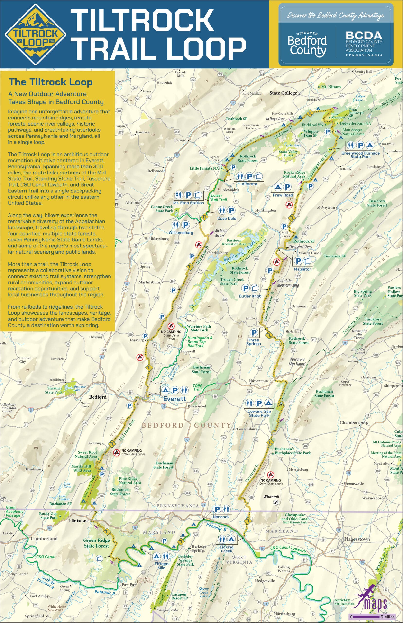
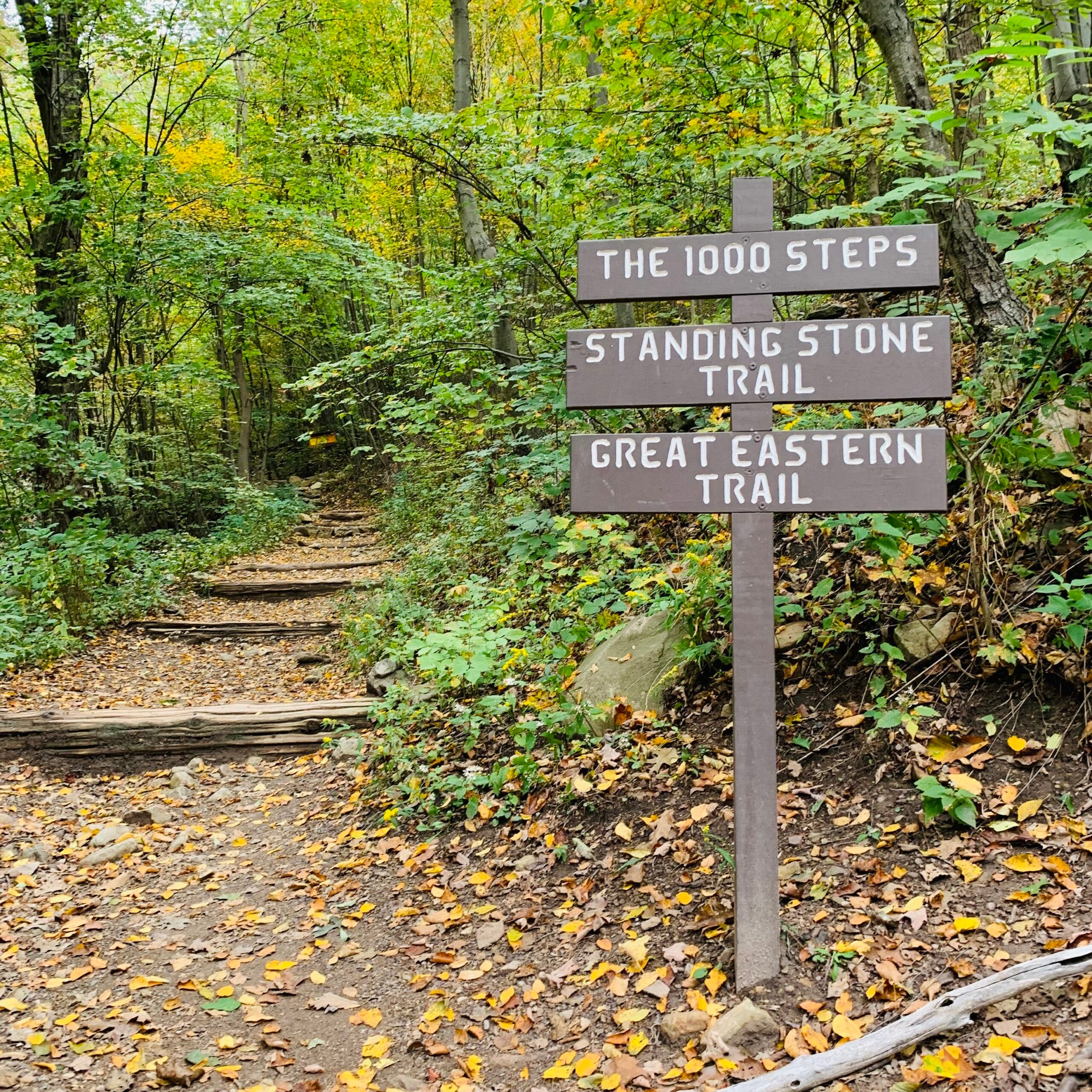
Furthermore, the map highlights notable geologic and historic waypoints along the route, such as the famous Thousand Steps on the Standing Stone Trail—a punishing stone stairway built by Ganister quarry workers in the early twentieth century—and sweeping vistas from the Standing Stone Overlooks. By pooling the intellectual resources of five separate trail-governing bodies, the creators of the Tiltrock Loop have effectively eliminated the guesswork typically associated with breaking trail on newly established routes.
Economic Impact and the Role of Trail Towns
A primary architectural advantage of the Tiltrock Loop is its circular configuration. Traditional long-distance trails, which run linearly from terminus to terminus, frequently demand complex logistical maneuvers, including long-distance vehicle shuttling, coordinated parking logistics, or thumbing rides on remote dirt roads. By contrast, the loop layout allows hikers to design their own itineraries, stepping onto and off the trail at numerous access points.
At the structural and cultural heart of this network lies Everett, Pennsylvania, a growing trail town nestled strategically along the remote stretches of the Mid State Trail. Local municipal leaders and economic development agencies deliberately positioned Everett to serve as the functional base camp and emotional anchor for the loop. Rather than functioning merely as a drive-through commuter hub along major regional highways, Everett has cultivated a welcoming infrastructure tailored specifically to the needs of long-distance backpackers.
Brooke Kelly, executive director of Discover Bedford County, emphasized the deliberate integration between the wilderness corridor and local communities. The goal, according to Kelly, was to give travelers a compelling reason to experience Bedford County mile by mile, bridging the gap between deep wilderness immersion and local economic vitality.
Today, Everett offers essential thru-hiker amenities, including family-owned lodging, diverse dining options, ice-cold provisions, and coin-operated laundromats—services often prized above all else after weeks on the trail. Beyond its utility as a resupply station, Everett provides accessible entry points for day-hikers and section-hikers looking to sample the region without committing to a full-scale expedition. Highlights accessible directly from the town include the challenging Everett Ridge section and the family-friendly Tenley Park Loop, which caters to casual visitors seeking a shorter outdoor excursion.
Implications for Regional Tourism and Outdoor Recreation
The debut of the Tiltrock Loop arrives at a time of surging interest in regional outdoor recreation and sustainable tourism across the Mid-Atlantic. By consolidating existing footpaths rather than cutting new paths through pristine forest canopy, the project represents a model of ecological efficiency and inter-organizational cooperation. Environmental impact is minimized by channeling foot traffic onto established, maintained rights-of-way while maximizing the utility of public lands.

For the outdoor recreation economy of Bedford County and surrounding jurisdictions, the loop is expected to draw a steady influx of regional and national tourism. Thru-hikers traversing the 300-mile circuit will inject vital capital into local micro-economies, supporting outfitters, lodging providers, grocers, and eateries in Everett and neighboring communities.
As the autumn season sets in and the first wave of prospective backpackers studies the freshly printed maps, the psychological allure of the trail remains potent. While thousands of hikers annually test their mettle on the crowded switchbacks of the Appalachian Trail, the Tiltrock Loop offers an entirely different proposition: true solitude, uncharted historical exploration, and the distinct honor of laying down the first official footprints on a modern American classic. For the adventurer willing to shoulder a pack across 33,000 vertical feet of rugged Pennsylvania ridgeline, the rewards are clear—and as local promoters point out, the door remains wide open for the first recorded Fastest Known Time.
Related posts: