Curaçao: A Comprehensive Guide to the Southern Caribbean’s Premier Cultural and Coastal Destination

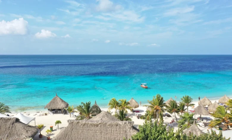
The island of Curaçao, a constituent country of the Kingdom of the Netherlands, has solidified its position as a cornerstone of Southern Caribbean tourism. Situated roughly 40 miles north of the Venezuelan coast, the island represents a unique convergence of Dutch colonial heritage, Afro-Caribbean culture, and a burgeoning ecological preservation movement. As global travel trends shift toward immersive, low-impact exploration, Curaçao has emerged as a primary candidate for travelers seeking a balance between urban history and protected natural landscapes.
The Historical and Economic Context of Willemstad
Willemstad, the capital city of Curaçao, is a UNESCO World Heritage site, recognized specifically for its historic area and harbor. The city is divided into two primary districts—Punda and Otrobanda—connected by the Queen Emma Pontoon Bridge, a floating structure that has been an iconic feature of the city since 1888. The architecture is characterized by its Dutch colonial design, featuring vibrant, pastel-colored facades that date back to the 17th and 18th centuries.
From an economic perspective, tourism remains a primary pillar of the Curaçaoan economy, contributing significantly to the island’s GDP. Local business initiatives, such as the bike-rental programs coordinated through hubs like Van Gogh Specialty Coffee in the city center, represent a growing movement to encourage "slow tourism." By utilizing bicycles, visitors reduce their carbon footprint while navigating the narrow, historic corridors of Pietermaai, Scharloo, and Otrobanda. These neighborhoods serve as open-air galleries, where mural-based street art projects—often commissioned by the local government to revitalize aging urban zones—have turned once-neglected walls into cultural landmarks.
The Geography and Geology of Curaçao’s Coastal Assets
The island’s topography is marked by arid, desert-like scrubland, rugged limestone cliffs, and protected bays known as bocas. Unlike the volcanic islands of the Eastern Caribbean, Curaçao is formed largely of limestone, which contributes to the exceptionally high clarity of its surrounding waters.
Data from local environmental agencies indicates that the island’s southern coast is protected by a nearly continuous fringing reef system. Beaches such as Playa Porto Mari are scientifically significant due to their "double reef" structure—a rare geological feature where a second coral reef sits parallel to the shore at a greater depth. This formation creates a unique ecological niche, supporting a high density of marine biodiversity, including sea turtles, parrotfish, and various species of rays.
Chronology of Regional Beach Development
The development of Curaçao’s beach infrastructure has followed a distinct timeline:
- 1950s–1970s: Initial focus on public access for local residents, with limited commercial development.
- 1990s: The rise of international tourism led to the commercialization of Jan Thiel and Mambo Beach. These areas were engineered to include modern amenities, such as beach clubs, restaurants, and artificial sand replenishment to facilitate higher foot traffic.
- 2010s–Present: A shift toward "eco-tourism" and conservation. Areas like Kenepa Beach (Knip Beach) have been strictly regulated to maintain their natural aesthetic. The government has implemented zoning laws to prevent over-development on the western side of the island, preserving the "wild" character of Grote Knip.
Comparative Analysis of Coastal Destinations
For the modern traveler, selecting a beach in Curaçao depends largely on the desired experience. Official tourism data classifies these locations into two tiers:
- Urban/Commercial Hubs: Jan Thiel and Mambo Beach provide proximity to infrastructure. These locations are the primary economic drivers for the service sector, featuring high-speed internet, extensive dining options, and structured water sports activities. They are best suited for families and groups requiring convenience.
- Nature-Centric/Remote Sites: Locations such as Grote Knip and Kenepa Beach offer minimal facilities, which serves as a deliberate strategy to limit human impact. Environmental analysis suggests that these areas maintain superior water quality metrics compared to the high-traffic urban beaches, as the surrounding cliff formations provide a natural buffer against runoff and erosion.
The Klein Curaçao Expedition: A Case Study in Managed Tourism
Klein Curaçao, an uninhabited island located approximately 15 miles off the southeastern coast of the main island, serves as a significant case study in controlled tourism. The island, which is only 1.7 square kilometers in size, was once used for phosphate mining and as a quarantine station in the 19th century. Today, it is primarily a day-trip destination for snorkelers and divers.
The management of Klein Curaçao is handled through a limited number of authorized concessions. Companies like Mermaid Boat Trips and Miss Ann Boat Trips hold the exclusive rights to operate permanent facilities on the island. This model is intentional; by centralizing tourist activity at these two locations, the government effectively creates a "containment zone." This prevents the degradation of the island’s interior, which features a historic, abandoned lighthouse and the remains of several shipwrecks. Experts argue that this model of "concession-based visitation" is essential for the preservation of fragile, uninhabited ecosystems.
Environmental Implications and Sustainable Development
The rapid growth of the tourism sector in Curaçao has necessitated a robust debate regarding sustainability. The Caribbean Tourism Organization (CTO) has recently emphasized that Curaçao’s reliance on its natural coastal beauty makes it highly vulnerable to climate change. Rising sea levels and the acidification of the ocean threaten the very reefs that define the island’s tourism product.
In response, local authorities have begun integrating "Blue Economy" principles into their planning. This involves:
- Coral Restoration Programs: Local research groups, often in partnership with international universities, are currently piloting coral nurseries to replenish reef sections damaged by storms or excessive tourism.
- Waste Management Initiatives: As part of the national tourism strategy, businesses are being incentivized to transition away from single-use plastics, particularly at beach-side establishments where waste can easily migrate into the marine environment.
- Infrastructure Hardening: The historic district of Willemstad is undergoing continuous restoration to protect its colonial architecture from salt-air corrosion and rising humidity, ensuring the longevity of these cultural assets for future generations.
Conclusion: Future Outlook
Curaçao represents a complex destination where the preservation of 17th-century European architecture meets the demands of 21st-century environmental stewardship. The island’s strategy of separating high-density urban tourism from low-impact ecological exploration appears to be a viable path forward for the Caribbean region.
For the visitor, the island offers a duality: the ability to engage with a vibrant, modern city on a bicycle in the morning, and the opportunity to swim in an untouched, protected bay by the afternoon. As international travel continues to rebound and expand, the island’s ability to maintain these distinct zones—the urban, the commercial, and the pristine—will be the defining factor in its long-term viability as a premier global destination. The data suggests that while the island faces significant challenges regarding climate change and infrastructure maintenance, its commitment to a managed, thoughtful approach to tourism provides a stable foundation for the foreseeable future.