The Ultimate 6-Day California Road Trip: Yosemite, Kings Canyon, and Sequoia National Parks

The revival of regional travel and domestic road trips has placed California’s Sierra Nevada region under a sharp economic and recreational spotlight, particularly routes connecting the state’s most prominent federally managed public lands. A primary example is the state-promoted "Majestic Mountain Loop," a roughly 200-mile circuit linking Yosemite, Kings Canyon, and Sequoia National Parks. Designed to eliminate the inefficiencies of backtracking from major metropolitan hubs like Los Angeles or San Francisco, this linear itinerary utilizes Fresno Yosemite International Airport as its primary aviation gateway. By anchoring travel around lesser-known regional base towns such as Bass Lake, Oakhurst, and Visalia, the route seeks to distribute visitor congestion while optimizing travel times through the rugged terrain of the Sierra Nevada mountain range.

Geographical Context and Route Engineering

The structural integrity of the Majestic Mountain Loop relies on a strategic sequence of driving distances that mitigate driver fatigue while maximizing access to geographically complex environments. Starting at Fresno, motorists travel northeast along Highway 41 into the Sierra foothills. The initial leg terminates near Bass Lake and Oakhurst, approximately 15 miles south of Yosemite National Park’s southern entrance. This positioning allows travelers to bypass the extended transit windows associated with longer-haul commutes from the Central Valley floor.

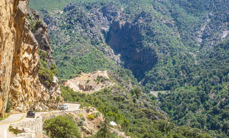
From the southern base, the itinerary progresses north into Yosemite Valley and the high-elevation overlooks of Glacier Point. After two to three days within Yosemite, the route transitions south via Highway 180 toward Kings Canyon National Park and descends through the Kings Canyon Scenic Byway—a vertical drop of 4,000 feet into one of North America’s deepest river gorges. The final segment positions visitors in Visalia, an agricultural hub functioning as the western gateway to Sequoia National Park, before looping back to Fresno or extending toward coastal transit nodes like San Francisco.

Chronological Itinerary and Operational Milestones

Day 1: Arrival and Foothill Acclimatization
Travelers arriving at Fresno Yosemite International Airport clear baggage claim quickly due to the facility’s compact footprint. The journey continues northeast on Highway 41 toward Bass Lake, a reservoir community operating outside the high-density footprint of Yosemite proper. The afternoon is dedicated to baseline acclimatization, water-based recreation, and lodging check-ins at local resorts or cabin rentals. Evening programming often features historical infrastructure tours, such as the Yosemite Mountain Sugar Pine Railroad, offering a narrow-gauge steam train experience and contextualizing the region’s 19th-century timber industry.

Day 2: Yosemite Valley and Hydrological Landmarks
Morning logistics demand early execution, with transit authorities and park operators recommending entry through the southern gates before 8:00 AM to secure vehicle parking and mitigate visitor bottlenecks. The focal point of Day 2 is the Mist Trail, a 3-mile round-trip ascent to Vernal Falls (with an optional 7-mile extension to Nevada Falls). The route features hundreds of granite steps subjected to heavy mist spray from the Merced River runoff. The afternoon is reserved for lower-elevation exploration, including Yosemite Falls, El Capitan Meadow, and Tunnel View.

Day 3: High-Altitude Panoramas and Ancient Groves
The third day centers on Glacier Point Road, bringing motorists to an elevation of 7,200 feet for panoramic vistas of Half Dome and the valley floor below. Secondary options include Taft Point, characterized by unfenced granite ledges overlooking a 3,000-foot drop. The return journey incorporates a stop at Mariposa Grove, home to mature giant sequoias (Sequoiadendron giganteum), providing a geological prelude to the more extensive forest ecosystems encountered later in Sequoia National Park.

Day 4: Canyon Descents and Agricultural Gateways
Leaving the Bass Lake area, travelers drive approximately two hours southeast to Kings Canyon National Park. The park highlights the General Grant tree—the third-largest known living tree in the world by volume—located within the Grant Grove section. The highlight of the day is the Kings Canyon Scenic Byway (Highway 180), which drops 4,000 feet into Cedar Grove. Here, the South Fork of the Kings River carves through a wide, glacier-carved valley. By late afternoon, motorists transit out of the canyon toward Visalia, a Central Valley city of approximately 140,000 residents that serves as an economic and cultural anchor for the southern Sierra parks.

Day 5: Alpine Ridges and the World’s Largest Tree
Day 5 focuses on Sequoia National Park, initiating with Moro Rock, a granite dome accessible via a 350-step stairway that delivers 360-degree views of the Great Western Divide. The itinerary proceeds to the Giant Forest, where visitors access the General Sherman tree. Containing 52,508 cubic feet of wood volume, the specimen represents the largest known living single-stem tree on Earth. Afternoon excursions typically include the Congress Trail, a mostly flat, two-mile loop weaving through dense clusters of mature sequoias.

Day 6: Departure and Urban Transitions
The final morning offers flexible departure scheduling depending on outbound travel logistics. Visitors returning via Fresno experience a concise 50-minute transit window, while those connecting to San Francisco or Los Angeles navigate a three-to-four-hour highway journey across the Central Valley.

Economic and Logistical Data

Financial and operational planning for the Majestic Mountain Loop requires consideration of several key variables:

- Entrance Fees: Individual park fees are standardized at $35 per vehicle for Yosemite and a combined $35 for Sequoia and Kings Canyon. The federal America the Beautiful interagency pass, priced at $80 annually, covers entry across all three jurisdictions, achieving cost-efficiency by the second day of the trip.
- Vehicle Requirements: While seasonal shuttle services operate within Yosemite Valley and during peak summer months between Visalia and Sequoia National Park, a personal or rental automobile remains a logistical necessity for traversing the inter-park transfers and regional byways.
- Seasonal Constraints: Peak tourism occurs during July and August, generating significant vehicular congestion. Late September and early October represent an optimal shoulder season, balancing reduced visitor densities with fully open roadways, though seasonal snowpacks can restrict high-elevation routes like Glacier Point Road and Tioga Pass outside the May-to-October window.
Socioeconomic Impact on Regional Communities

The routing strategy of the Majestic Mountain Loop highlights a deliberate effort by regional tourism boards to distribute visitor spending beyond gateway bottlenecks. Towns like Oakhurst, Bass Lake, and Visalia capture economic benefits traditionally concentrated solely inside federal park concessions. Visalia, in particular, leverages its agricultural output and urban infrastructure to provide dining and lodging alternatives that insulate travelers from premium pricing models often found within national park boundaries.

Furthermore, infrastructure partnerships—such as the seasonal Sequoia Shuttle operated by the City of Visalia—reflect broader municipal initiatives to mitigate carbon footprints and alleviate parking shortages inside Sequoia National Park’s narrow, winding entry corridors. As federal land managers continue to evaluate visitor capacity limits and reservation frameworks across the National Park System, structured regional loops like the Majestic Mountain Loop offer a sustainable blueprint for balancing recreational demand with environmental preservation.