Fractals in the Dirt: Unveiling the Geological Significance and Ecological Impact of the Mancos Shale on the Colorado Plateau

The Mancos Shale, an expansive and frequently overlooked geological formation underlying vast stretches of the American West, has increasingly become a focal point for geologists, environmental scientists, and land-management agencies. Spanning an estimated 90 million years of Earth’s history, this Late Cretaceous mudstone covers tens of thousands of square miles across New Mexico, Arizona, Colorado, Wyoming, and Utah. While often dismissed by casual travelers as mere barren badlands or a dusty roadside nuisance, the formation holds profound scientific value, heavily influencing regional hydrology, infrastructure stability, and energy development across the Colorado Plateau.
Main Facts and Geological Origins
Deposited during the Late Cretaceous period—approximately 90 million years ago—the Mancos Shale originated at the bottom of the Western Interior Seaway. This massive inland sea stretched from the Arctic Ocean to the Gulf of Mexico, dividing North America into two distinct landmasses: Laramidia to the west and Appalachia to the east.
Over millions of years, the sea floor accumulated thick layers of fine-grained marine sediment, organic matter, and volcanic ash. As tectonic forces uplifted the region and the seaway receded, these compressed sediments transformed into a thick, highly friable gray-blue-brown mudstone and shale.
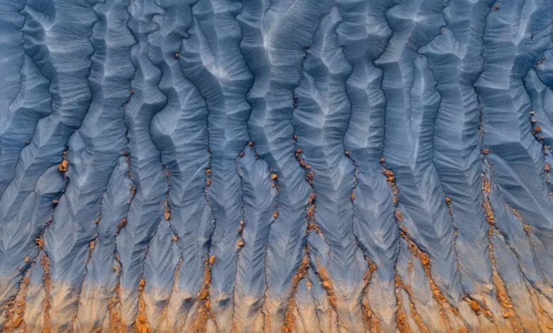
Today, the formation varies significantly in thickness, reaching up to several thousand feet in certain structural basins. Because the rock is exceptionally soft and prone to weathering, it yields distinctive topography characterized by expansive badlands, swelling clay soils, and intricate, dendritic drainage patterns often visible from the air as mathematical fractals etched into the earth.
Chronology of Scientific and Industrial Interaction
The historical relationship between human activity and the Mancos Shale spans from early indigenous uses to modern industrial extraction:
- Late Cretaceous (90 Million Years Ago): Deposition of marine sediments within the Western Interior Seaway begins, forming the precursor layers of the Mancos Shale.
- Late 19th to Early 20th Century: Early geological surveys of the American West, led by pioneers such as John Wesley Powell and Ferdinand Vandeveer Hayden, map out the complex stratigraphy of the Colorado Plateau, identifying the extensive reach of Cretaceous shales.
- Mid-20th Century: With the post-World War II energy boom, federal and state agencies begin evaluating the region for oil, natural gas, and uranium resources, noting the presence of hydrocarbon-rich layers within the Mancos formation.
- Late 20th to Early 21st Century: Advances in horizontal drilling and hydraulic fracturing unlock vast energy reserves trapped within tight shale formations, transforming the Mancos Shale into a significant target for natural gas production, particularly in the San Juan and Piceance basins.
- Present Day: Environmental scientists, hydrologists, and civil engineers intensify monitoring efforts to mitigate the unique hazards posed by the formation, including soil erosion, saline runoff into the Colorado River system, and structural shifting beneath regional infrastructure.
Supporting Data and Hydrological Implications
The physical and chemical properties of the Mancos Shale present distinct challenges to both natural ecosystems and human development. Composed largely of smectite and other expanding clays, the formation swells significantly when wet and shrinks dramatically upon drying. This constant volumetric fluctuation creates severe geotechnical hazards, frequently resulting in cracked highway pavements, damaged building foundations, and accelerated slope instability.
Furthermore, the Mancos Shale is notoriously rich in soluble salts, selenium, and other trace minerals derived from its ancient marine origins. When precipitation falls on exposed badlands, runoff dissolves these minerals, carrying high concentrations of salt and selenium into major waterways, most notably the Colorado River and its tributaries.
According to data compiled by the U.S. Geological Survey (USGS), weathering and irrigation return flows over Mancos Shale terrains contribute millions of tons of dissolved solids to the Colorado River system annually. This high salinity degrades downstream agricultural productivity, corrodes municipal infrastructure, and threatens endangered native fish species through selenium bioaccumulation.
Official Responses and Land-Management Strategies
Federal agencies, including the Bureau of Land Management (BLM) and the USGS, have implemented targeted monitoring and mitigation programs to address the ecological and structural complexities associated with the Mancos Shale.
Water resource managers have focused heavily on salinity-control projects, such as lining irrigation canals to prevent water from seeping into underlying shale layers and leaching heavy minerals into the river network. The U.S. Department of Agriculture’s Natural Resources Conservation Service (NRCS) has partnered with regional farmers to improve irrigation efficiency, thereby reducing the volume of saline runoff entering public waterways.
In the energy sector, regulatory bodies enforce strict well-construction and wastewater-disposal standards to prevent drilling operations within the Mancos formation from contaminating regional aquifers. Given the propensity of the shale to shift under heavy loads, civil engineering firms operating in Colorado, Utah, and New Mexico now require rigorous geotechnical site assessments before initiating large-scale construction projects in shale-heavy zones.
Broader Impact and Future Outlook
As climate patterns shift across the American Southwest, the fragile ecosystems sustained by or impacted by the Mancos Shale face mounting pressures. Accelerated erosion from intense precipitation events threatens to increase sediment and salt loads in regional reservoirs already strained by prolonged drought.
At the same time, the formation remains a vital component of the nation’s energy portfolio, balancing traditional extraction interests with modern environmental safeguards. Interdisciplinary research combining geology, hydrology, and civil engineering continues to shed light on how this vast, unassuming mudstone shapes the physical reality of the Colorado Plateau.
Far from being an empty wasteland, the Mancos Shale stands as a dynamic, complex geological archive—one that actively dictates the environmental health, economic stability, and infrastructure resilience of the American West.