The Tiltrock Loop: A 300-Mile Thru-Hike Unites Five Historic Trails Across Pennsylvania and Maryland


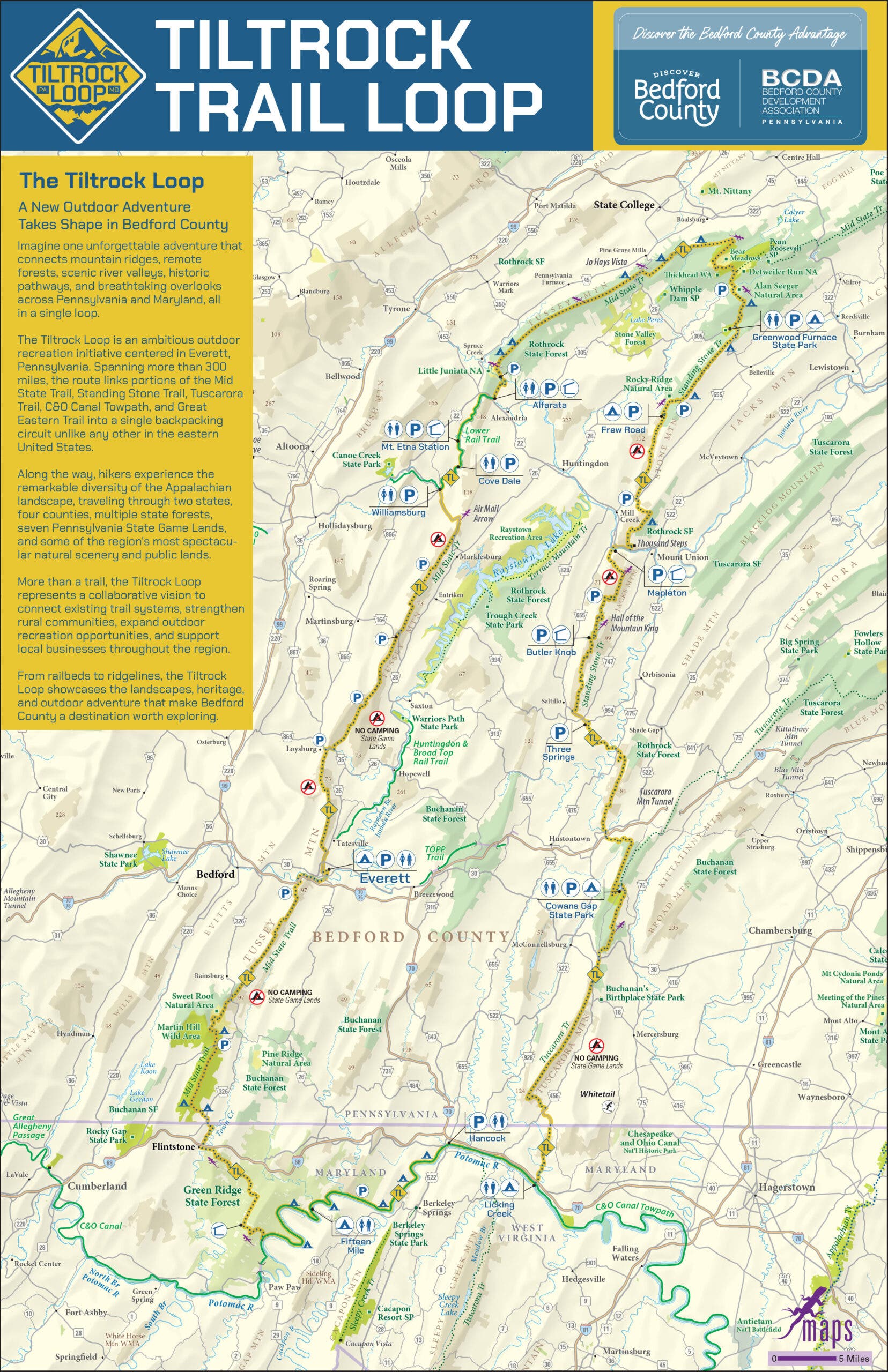
For decades, long-distance backpacking enthusiasts in the United States have focused their attention on established mega-routes like the Appalachian Trail, the Pacific Crest Trail, and the Continental Divide Trail. While these marquee pathways command international acclaim, they often require monumental life disruptions, complex logistical shuttles, and months of isolation. Recognizing a gap in the outdoor recreation landscape, regional planners, outdoor alliances, and local trail groups have officially introduced the Tiltrock Loop: a continuous 300-mile circuit traversing south-central Pennsylvania and northern Maryland. Designed to be completed in roughly a month, this new route bridges five distinct historic trails, offering a rugged, culturally rich backcountry experience without demanding a six-month commitment from its participants.
The inception of the Tiltrock Loop represents a significant milestone in regional trail planning, merging deep-forest exploration with community integration. As the route officially opens to the public, it introduces a pristine challenge for thru-hikers seeking solitude, historical immersion, and the rare opportunity to claim an inaugural Fastest Known Time (FKT) on a brand-new multi-state loop.

Genesis of the Route: From Concept to Collaboration
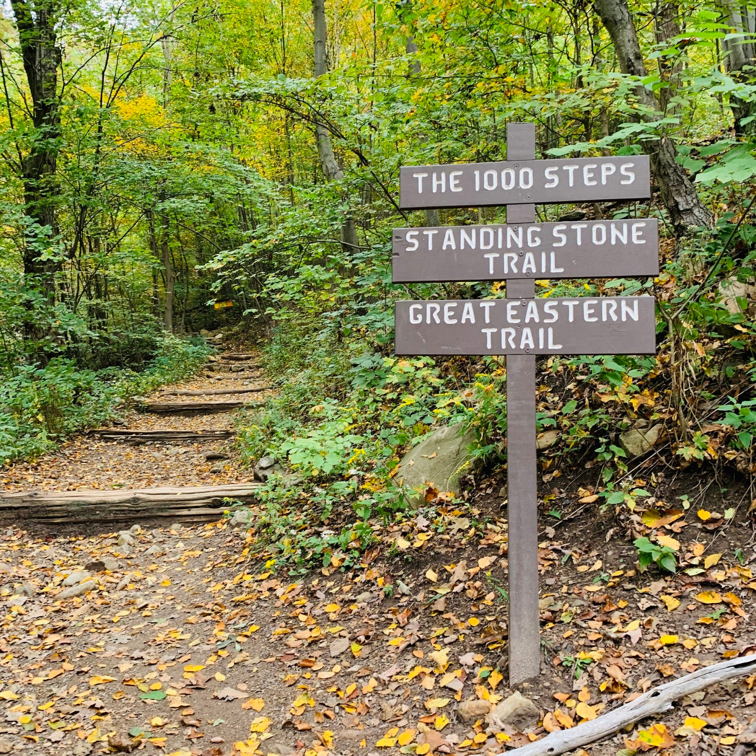
The creation of the Tiltrock Loop began as an organic observation by avid local hiker Mike Teeter. While analyzing regional topography and trail networks, Teeter realized that a recent rerouting of the expansive 1,800-mile Great Eastern Trail had inadvertently established the geographic framework for a complete circuit. By strategically connecting portions of the Great Eastern Trail, the C&O Canal Towpath, the Mid State Trail, the Tuscarora Trail, and the Standing Stone Trail, a continuous loop across the slanted Allegheny ridgelines became mathematically and logistically possible.
What started as a cartographical realization quickly evolved into a broad grassroots initiative. Teeter partnered with the Bedford County Outdoor Recreation Alliance to pitch the concept to regional stakeholders. Historically, unifying multiple trail systems presents immense bureaucratic and administrative hurdles, as disparate volunteer associations, state agencies, and private landowners must coordinate management strategies, maintenance protocols, and mapping standards.
However, the proposal met with unprecedented enthusiasm. Jennifer Marsh, head of the Bedford County Development Association, noted the speed with which the various groups mobilized. Representatives from all five participating trail associations, alongside local government agencies and cartographic experts, immediately endorsed the vision. This spirit of cooperation transformed a theoretical map overlay into an actionable infrastructure project, culminating in the official launch of the Tiltrock Loop.

Anatomy of the Loop: Terrain, Logistics, and Data
Spanning 300 miles across Pennsylvania and Maryland, the Tiltrock Loop is engineered to challenge even seasoned backpackers while remaining manageable for working professionals. The route is characterized by a demanding total elevation gain of 33,372 feet, navigating rocky ridgelines, deep river valleys, and dense canopies. Despite its challenging topography, the loop tops out at a modest highest elevation of 2,727 feet, keeping extreme altitude sickness risks at bay while still delivering dramatic panoramic vistas.
Navigation and preparation are critical components of a successful thru-hike on the Tiltrock Loop. Because the route incorporates five separate trail systems, water availability fluctuates significantly depending on seasonal precipitation and regional weather patterns. Outdoor experts recommend that hikers carry a minimum of three liters of water per day and maintain a self-supported food supply capable of sustaining them for three to five days between resupply points.
Camping infrastructure along the loop is diverse, featuring a combination of established backcountry shelters, primitive campsites, and designated remote areas. Hikers must strictly adhere to regional regulations, particularly when traversing Pennsylvania State Game Lands, where camping rules are strictly enforced. To assist backcountry travelers, Purple Lizard Maps—a Pennsylvania-based cartography firm renowned for its detailed regional guides—partnered with the initiative to produce an official map. The publication clearly delineates water sources, campsite locations, resupply towns, and regulatory boundaries, marked with the company’s signature lizard icons at key points of interest.
Historical Context and Cultural Significance
Beyond its physical demands, the Tiltrock Loop serves as an outdoor museum of industrial and transportation history. The Allegheny Mountains and surrounding valleys played a pivotal role in America’s industrial expansion during the 19th and 20th centuries. As hikers traverse the ridgelines and forest floors, the trail frequently intersects the remnants of former coal mining operations, old-growth timber logging roads, and abandoned infrastructure from never-completed railroad projects.
These historical artifacts provide a tangible connection to the past, reminding travelers of the laborers, engineers, and industrialists who once shaped the rugged terrain. By integrating these historical sites into a unified recreation corridor, the Tiltrock Loop preserves local heritage while promoting conservation and public land appreciation.
Economic and Community Impact on Trail Towns
A defining feature of the Tiltrock Loop is its circular configuration, which fundamentally alters the logistics typically associated with long-distance backpacking. Traditional point-to-point trails often necessitate complicated shuttle arrangements, long-distance hitchhiking, or the parking of vehicles at isolated trailheads vulnerable to break-ins. The loop layout allows hikers to start and finish at any point along the circuit, significantly streamlining travel planning.
Planners deliberately designed the route to weave through local communities, maximizing the economic and social benefits for rural towns historically bypassed by major interstate traffic. Brooke Kelly, executive director of Discover Bedford County, emphasized that the project’s goal extended far beyond simply attracting tourists.
"We weren’t interested in creating another reason to simply drive through Bedford County; we wanted to give people a reason to experience it mile by mile," Kelly stated. "The Tiltrock Loop connects some incredibly wild places, but it also connects hikers to the surrounding communities. That combination is what makes this trail different."
At the logistical and cultural heart of the loop lies Everett, Pennsylvania. Serving as an ideal base camp, Everett offers thru-hikers essential amenities, including family-owned restaurants, lodging options, grocery stores, and laundromats—services that are often vital after weeks on the trail. The town also provides access to scenic regional segments, such as the Everett Ridge section and the family-friendly Tenley Park Loop, allowing day-hikers and section-hikers to sample the broader trail experience.

Broader Implications and Future Outlook
As the Tiltrock Loop enters its inaugural season, its emergence reflects a broader evolution in American outdoor recreation. Increasingly, regional planners are recognizing the value of leveraging existing infrastructure rather than clearing new land, creating sophisticated multi-use corridors that stimulate local economies while safeguarding natural habitats.
For the endurance community, the trail presents a unique psychological and physical challenge. Because the route is entirely new, no thru-hiker has yet logged an official completion time. This clean slate has sparked considerable interest among ultra-light backpackers and endurance athletes. As Jennifer Marsh noted regarding the appeal for early adopters, the first person to complete the circuit will automatically establish the Fastest Known Time for the route, adding a competitive edge to an otherwise contemplative wilderness journey.
Ultimately, the Tiltrock Loop bridges the gap between major national scenic trails and regional conservation efforts. By uniting five distinct paths into a cohesive 300-mile journey, Bedford County and its partners have established a durable blueprint for regional outdoor tourism—one that honors the industrial history of the Alleghenies while inviting a new generation of hikers to discover the rugged wilderness hidden just beyond the well-trodden Appalachian Trail.