The Tiltrock Loop: A 300-Mile Thru-Hike Unites Pennsylvania and Maryland’s Rugged Ridges


The landscape of long-distance backpacking in the Mid-Atlantic region has officially expanded with the introduction of the Tiltrock Loop, a continuous 300-mile trail that navigates the rugged terrain of south-central Pennsylvania and northern Maryland. Formally unveiled to the public in September 2026, the route bridges five distinct, established trail systems to create a unified circuit designed for thru-hikers seeking an alternative to heavily trafficked paths like the Appalachian Trail.
Spanning across slanted Allegheny ridgelines, deep forests, and historic river valleys, the loop accumulates a staggering 33,372 feet of total elevation gain while peaking at an elevation of 2,727 feet. Unlike traditional point-to-point routes that require intricate vehicle shuttles or difficult logistical planning, the Tiltrock Loop’s circular design allows travelers to begin and end their journey at the same location. Currently, the route stands as a blank slate for endurance athletes and backpackers, with no recorded thru-hike completions logged to date, offering a rare opportunity to claim a inaugural Fast Known Time (FKT) on a major American footpath.

Genesis of the Route: A Grassroots Collaborative Effort
The conceptualization of the Tiltrock Loop traces back to a geographic realization by avid local hiker Mike Teeter. While examining regional maps, Teeter noted that a recent rerouting of the 1,800-mile Great Eastern Trail had inadvertently generated a closed-circuit configuration. This layout linked the C&O Canal Towpath and the Mid State Trail to the west with the Tuscarora Trail and the Standing Stone Trail to the east.
Recognizing the potential for a premier regional backpacking experience, Teeter partnered with the Bedford County Outdoor Recreation Alliance to pitch the concept. What followed was an unusually rapid and harmonious period of inter-organizational cooperation. Bringing a multi-state trail project to fruition typically involves years of bureaucratic hurdles, negotiations over land use, and logistical consensus-building among disparate agencies. However, the proposal immediately resonated with regional stakeholders.
Jennifer Marsh, head of the Bedford County Development Association, noted the unprecedented enthusiasm from the five independent trail associations governing the constituent routes. State agencies, local municipalities, and conservation groups also joined the coalition, lending their cartographic and environmental expertise to officialize the unified route. The resulting collaboration successfully synthesized diverse segments into a single, cohesive itinerary accompanied by professionally compiled mapping resources.

Route Anatomy and Logistics: Navigating the 300-Mile Circuit
The Tiltrock Loop at a Glance:
- Distance: 300 miles
- Layout: Continuous loop
- Jurisdiction: Pennsylvania and Maryland
- Total Elevation Gain: 33,372 feet
- Highest Elevation: 2,727 feet
- Recommended Trailhead: Everett, Pennsylvania
- Terrain: Appalachian ridges, deep forests, and river valleys
- Estimated Thru-Hike Duration: Approximately 30 days
Traversing the loop requires careful preparation, as the trail samples some of the most remote and challenging topography in the commonwealth. Experts recommend that hikers allocate roughly one month to complete the entire 300-mile circuit. Because water availability fluctuates depending on seasonal precipitation patterns, backpackers are advised to maintain a capacity of at least three liters and carry three to five days of food supply between resupply points.
Accommodation along the route varies, integrating established backcountry shelters, primitive campsites, and designated wilderness areas. Because parts of the trail cross through Pennsylvania State Game Lands and protected public forests, users must strictly adhere to localized camping regulations, which are clearly delineated on the official maps produced in partnership with Purple Lizard Maps. Known for their signature branding, the cartography firm has marked critical waypoints, water sources, and resupply towns to assist navigators across the rugged terrain.
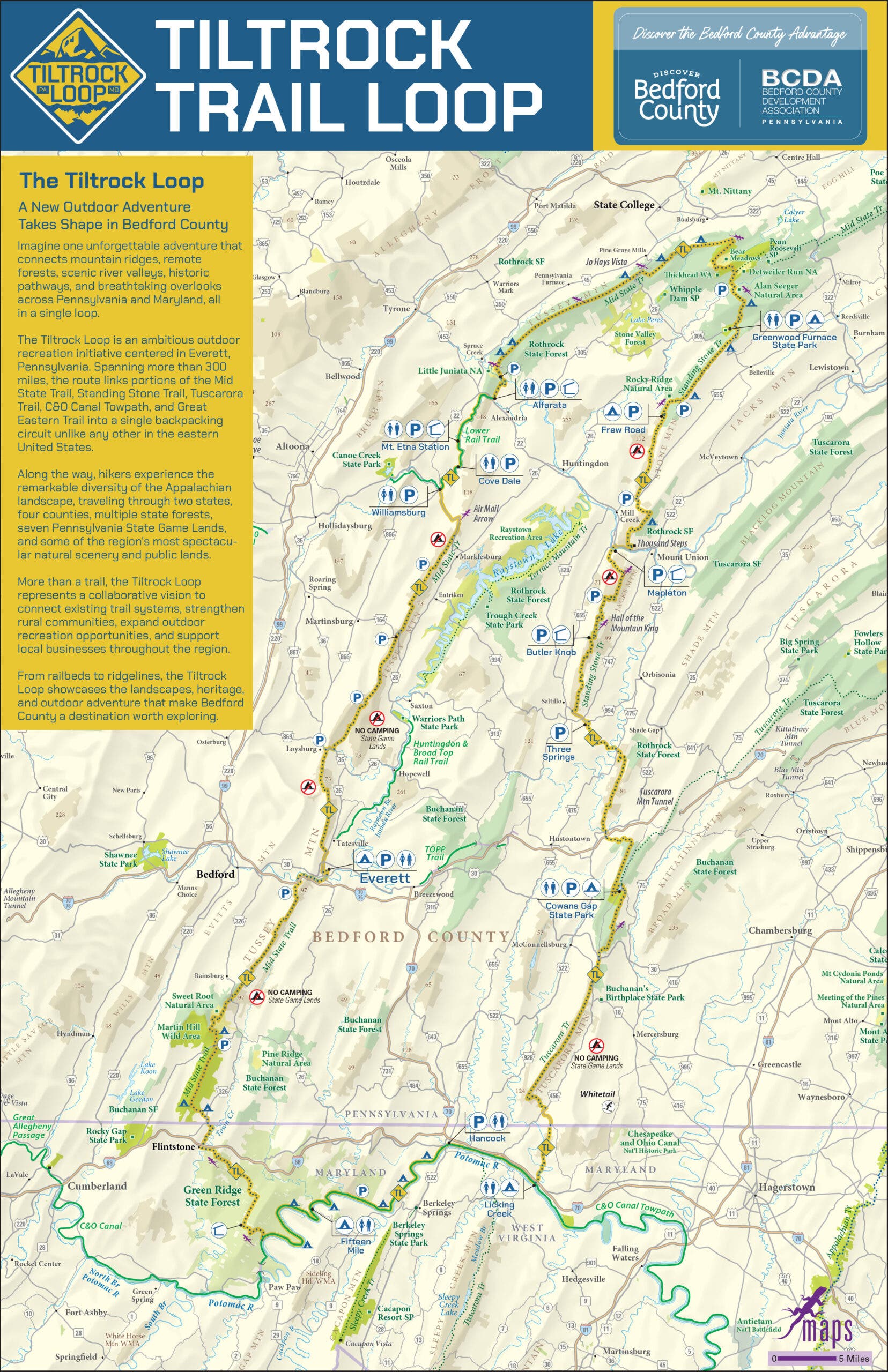
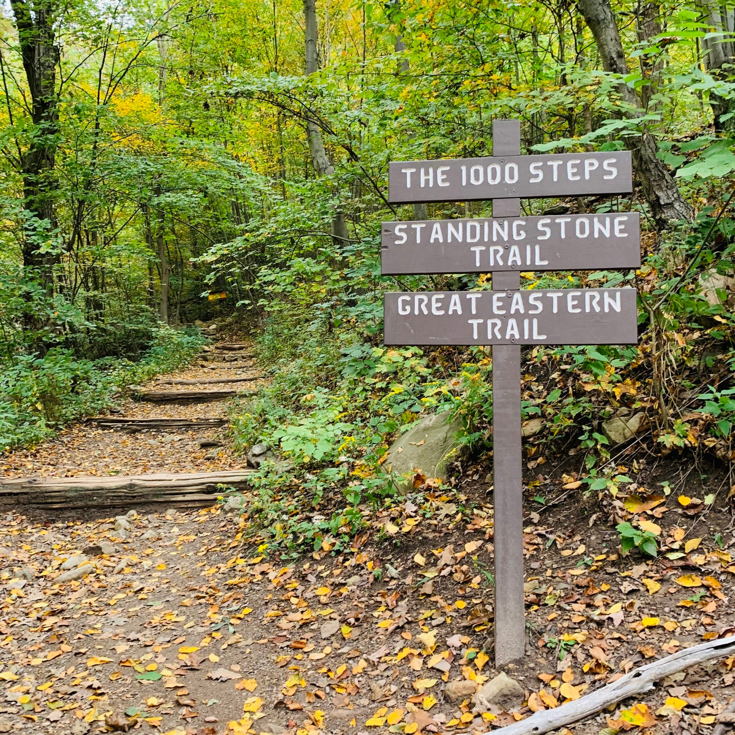
Beyond natural topography, the loop serves as an open-air museum of regional industrial history. Thru-hikers routinely encounter artifacts from Pennsylvania’s nineteenth- and twentieth-century coal mining operations, alongside abandoned grading and structural infrastructure from nineteenth-century railroad projects that were ultimately abandoned before completion. Notable landmarks along the way include the grueling physical challenge of the Thousand Steps on the Standing Stone Trail and expansive vistas from high-elevation rocky outcrops.
Economic and Community Impact on Trail Towns
While the primary appeal of the Tiltrock Loop lies in its wilderness isolation, its economic and social architecture is deeply tied to the surrounding communities, most notably the borough of Everett, Pennsylvania. Strategically positioned along the Mid State Trail corridor, Everett serves as the designated unofficial basecamp, start point, and finishing line for the circuit.
Local officials deliberately designed the project to integrate outdoor recreation with community development. Rather than routing travelers entirely around population centers, the loop intentionally channels foot traffic through historical towns to stimulate local commerce.
"We weren’t interested in creating another reason to simply drive through Bedford County; we wanted to give people a reason to experience it mile by mile," said Brooke Kelly, executive director of Discover Bedford County. "The Tiltrock Loop connects some incredibly wild places, but it also connects hikers to the communities surrounding them. That combination is what makes this trail different."
For thru-hikers completing a grueling 30-day trek, Everett offers essential amenities that are often absent in remote backcountry settings. The town provides family-owned lodging, restaurants, grocery resupply options, and essential hiker services, including laundromat facilities. Furthermore, the surrounding area features shorter excursions, such as the Everett Ridge section and the family-oriented Tenley Park Loop, catering to day-hikers and weekend backpackers who prefer segment hiking over long-distance treks.
Broader Implications for Regional Tourism and Conservation
The launch of the Tiltrock Loop arrives at a time when middle-distance thru-hiking routes are seeing a surge in demand. As traditional long-distance paths like the Appalachian Trail and the Pacific Crest Trail experience increasing congestion and strict permit systems, hikers increasingly seek alternative routes that offer solitude without requiring a six-month commitment.

By combining pre-existing trails rather than clearing entirely new corridors, the Bedford County Outdoor Recreation Alliance has demonstrated a sustainable model for regional outdoor infrastructure development. The project minimizes environmental disturbance while maximizing the utility of existing public lands and conservation easements across Pennsylvania and Maryland.
As the route enters its inaugural operational season, its unique status as an unclimbed thru-hiking frontier is expected to draw elite endurance athletes, regional backpackers, and outdoor media. Whether hikers tackle the entire 300-mile circuit to set the first documented Fastest Known Time or sample individual ridgeline segments from the comfort of Everett, the Tiltrock Loop establishes a new standard for collaborative trail design in the American Northeast.