Fractals in the Dirt: Unveiling the Geological and Ecological Significance of the Mancos Shale Across the American West

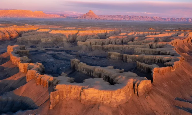
The Mancos Shale, an expansive and frequently misunderstood geologic formation spanning multiple states across the American West, commands the attention of geologists, environmental scientists, and land-use planners alike. Stretching across vast swaths of New Mexico, Arizona, Colorado, Wyoming, and Utah, this ancient marine deposit underlies some of the region’s most iconic landscapes. Formed approximately 90 million years ago during the Late Cretaceous epoch, the formation is a thick sequence of gray-blue-brown mudstone, siltstone, and sandstone that accumulated on the floor of the Western Interior Seaway—a massive shallow body of water that once split the North American continent in two.
While casual motorists traversing the highways of the Colorado Plateau may view the muted, eroded badlands of the Mancos Shale as barren wasteland, earth scientists recognize the formation as a complex archive of paleoclimate data and an active, dynamic participant in contemporary regional hydrology and infrastructure challenges.
Chronology of Formation and Depositional History
The geological narrative of the Mancos Shale began in the Late Cretaceous, specifically during the Cenomanian through Campanian stages, roughly 92 to 80 million years ago. During this period, tectonic activity associated with the Laramide orogeny began to reshape the western margin of the continent, while concurrent sea-level fluctuations caused the Western Interior Seaway to periodically expand and contract.
Fine-grained sediments, eroded from adjacent highlands and washed down by ancient river systems, settled into the deep, oxygen-poor waters of the seaway. Over millions of years, the accumulation of organic-rich muds compressed under thousands of feet of overlying strata, lithifying into the friable, easily weathered shale observed today. Subsequent tectonic uplift during the Cenozoic era elevated these marine sediments to the high-plateau elevations they occupy now, where surface erosion by wind, rain, and snowmelt continuously sculpts the landscape into intricate, fractal-like patterns of arroyos, gullies, and pediments.
Stratigraphy and Physical Characteristics
Lithologically, the Mancos Shale is characterized by its homogeneity and its susceptibility to physical and chemical weathering. The formation can reach thicknesses of up to 4,000 to 5,000 feet in certain depocenters, such as the San Juan Basin in New Mexico and the Uinta Basin in Utah.
Because the mudstones contain significant amounts of smectite and other expanding clay minerals, the formation exhibits pronounced shrink-swell behavior when exposed to moisture. During heavy precipitation events, the surface layer absorbs water, swells into a sticky, impassable mud, and loses structural integrity. Conversely, during dry periods, the sediment shrinks and fractures extensively, creating a network of desiccation cracks that accelerate mechanical erosion during subsequent storms.
Hydrological and Environmental Implications
The unique geochemical and physical properties of the Mancos Shale have profound implications for regional water quality, agriculture, and civil engineering.
When irrigated or exposed to meteoric water, the marine shales readily leach soluble salts, primarily sodium, magnesium, and calcium sulfates, into local and regional watershed systems. The United States Geological Survey (USGS) and other federal water management agencies have long monitored the Mancos Shale as one of the primary natural contributors of dissolved solids and salinity to the Colorado River basin. High salinity levels in the Colorado River impose substantial economic costs on downstream agricultural users in Arizona, California, and Mexico, as well as municipal water treatment facilities serving millions of residents.
Furthermore, selenium—a naturally occurring trace element concentrated within certain marine sedimentary layers of the Mancos—frequently leaches into soils and waterways. Elevated selenium concentrations in agricultural runoff and river systems have been linked to reproductive failure and developmental abnormalities in native fish species and migratory birds, prompting extensive interagency mitigation and remediation programs.
Infrastructure and Land-Use Challenges
For civil engineers and transportation departments operating within the Colorado Plateau, the Mancos Shale presents persistent structural hazards. The low shear strength of weathered mudstone, combined with its high plasticity and shrink-swell characteristics, makes it a notoriously unstable foundation material for highways, bridges, and residential developments.
Roadways constructed directly on top of or through Mancos Shale formations frequently experience differential settling, slope failures, and severe pavement buckling. State departments of transportation in Colorado, Utah, and New Mexico routinely allocate substantial portions of their maintenance budgets to slope stabilization, retaining wall installation, and subgrade soil remediation in areas dominated by the formation.
Resource Potential and Paleontological Significance
Despite its challenges, the Mancos Shale holds considerable economic and scientific value. In various structural basins across the West, organic-rich facies within the formation serve as important petroleum source rocks and emerging targets for unconventional oil and natural gas exploration via horizontal drilling and hydraulic fracturing.
Concurrently, paleontologists value the formation for its rich fossil record. The marine sediments preserve a diverse assemblage of Late Cretaceous invertebrates, including ammonites, inoceramid bivalves, and gastropods, as well as vertebrate remains such as marine reptiles (mosasaurs and plesiosaurs) and occasional dinosaur bones washed down from nearby terrestrial habitats. These fossils provide critical benchmarks for biostratigraphic correlation and paleoecological reconstruction of the ancient seaway ecosystem.
Broader Impact and Future Outlook
As climate patterns shift and human demands on western water resources intensify, interdisciplinary interest in formations like the Mancos Shale continues to grow. Managing the delicate balance between resource extraction, infrastructure maintenance, and watershed protection requires ongoing collaboration among geologists, hydrologists, environmental regulators, and civil engineers.
Far from being a mere aesthetic backdrop to desert highway journeys, the Mancos Shale remains an active, defining architectural element of the American West—shaping the physical terrain, influencing water security, and recording millions of years of earth history in its dusty, fractal-patterned outcrops.