Guatemala Travel Guide 2026: Essential Itineraries, Modern Logistics, and Border Regulations for Travelers

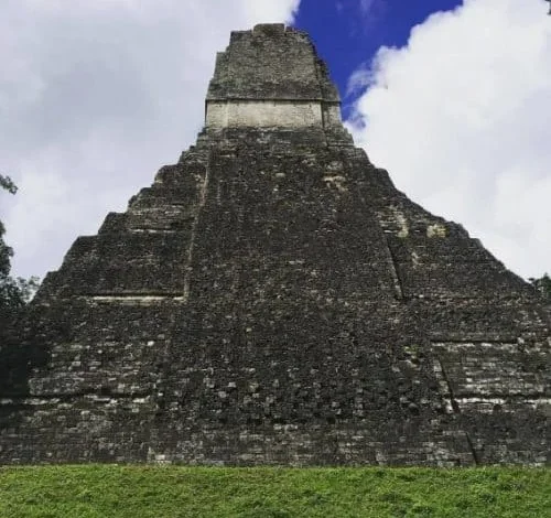
Guatemala continues to solidify its position as one of Central America’s premier cultural and ecological destinations, drawing hundreds of thousands of international visitors annually to its volcanic highlands, colonial architecture, and deep jungle ruins. Long recognized for its diverse topography and rich Mayan heritage, the nation requires careful navigation by modern travelers due to shifting regional border frameworks, localized security advisories, and evolving infrastructure. Recent developments in transportation, digital connectivity, and park regulations have streamlined the visitor experience across the country’s primary tourism corridors, while official oversight remains strict regarding environmental conservation and public safety.
Comprehensive Border Frameworks and Financial Logistics for 2026

International travelers entering Guatemala must navigate the stringent protocols of the Central America-4 (CA-4) Border Control Agreement. Encompassing Guatemala, Honduras, El Salvador, and Nicaragua, the CA-4 treaty permits citizens of numerous nations, including the United States, to enter the member countries visa-free for up to 90 days. However, immigration authorities enforce a unified clock; crossing a land border into Honduras or El Salvador does not reset the initial 90-day tourist visa allotment. Visitors seeking to extend their stay must apply for a single 90-day extension at the central immigration office in Zone 4 of Guatemala City, a process that incurs a standard administrative fee of $25. Furthermore, foreign passports must maintain a minimum validity of six months beyond the planned date of departure.
Financial planning within Guatemala remains heavily reliant on physical currency outside major metropolitan centers. The national currency, the Guatemalan quetzal (Q), has maintained a stable exchange rate hovering between Q7.60 and Q7.80 per U.S. dollar for several years. Despite the widespread acceptance of credit cards in upscale hotels and restaurants in Antigua and Guatemala City, cash is mandatory for regional transport, national park admissions, and excursions in remote areas. Notably, popular destinations such as Lanquín and the Semuc Champey monument lack reliable automated teller machine (ATM) infrastructure, necessitating that travelers secure sufficient local currency prior to departure from major hubs.
From a connectivity standpoint, modern infrastructure has reduced the friction traditionally associated with remote travel. The widespread adoption of embedded subscriber identity module (eSIM) technology, such as services provided by Saily, allows international visitors to activate local data packages prior to arrival. This eliminates the logistical hurdles of sourcing physical SIM cards upon landing at La Aurora International Airport in Guatemala City, ensuring continuous navigation and communication capabilities along the tourist corridor spanning Antigua, Lake Atitlán, and the Petén department.

Official Security Assessments and Regional Travel Advisories
The United States Department of State maintains a Level 3 travel advisory for Guatemala, categorized as "Reconsider travel," citing localized crime and inadequate emergency infrastructure in specific regions. Within the national territory, four specific departments or administrative zones carry a Level 4 advisory ("Do not travel"): the departments of San Marcos and Huehuetenango, Zone 18 of Guatemala City, and the municipality of Villa Nueva. Official tourism boards and foreign ministries emphasize that these high-risk areas remain entirely outside the conventional tourist circuit.
For travelers adhering to the primary tourism corridors—specifically Antigua, Lake Atitlán, Tikal, and Río Dulce—risk mitigation primarily involves standard prudent behaviors. Authorities recommend utilizing reputable tourist shuttle services rather than public transit for inter-city travel, avoiding unessential driving after dark, and utilizing official transport hubs. The nation experiences distinct seasonal weather patterns; the dry season, extending from November through April, serves as the optimal period for outdoor exploration, whereas the rainy season from May through October frequently induces trail degradation, restricted water visibility, and logistical delays.

Antigua Guatemala: Colonial Heritage and Volcanic Exploration
Situated approximately 40 kilometers west of Guatemala City, Antigua serves as the primary gateway for international visitors. Founded as the capital of the Kingdom of Guatemala in 1542, the city suffered catastrophic damage from a series of earthquakes in 1773, prompting the relocation of the administrative center to modern-day Guatemala City. The preserved ruins, cobblestone streetscapes, and surrounding stratovolcanoes—Agua, Fuego, and Acatenango—have established Antigua as a UNESCO World Heritage site and a cornerstone of the national economy.
Transit from La Aurora International Airport to Antigua typically requires an hour during off-peak hours, though rush-hour congestion can extend transit times to three hours. Travelers utilize shared shuttles ranging from $15 to $20 per person, private transfers priced between $40 and $60, or local public transport (chicken buses) for roughly Q25.

The region’s most prominent adventure tourism offering involves overnight ascents of Mount Acatenango to observe the continuous strombolian activity of the adjacent Volcán Fuego. Fuego has exhibited near-continuous activity since 2002, ejecting incandescent material at regular intervals throughout the night. Following a significant paroxysmal event in August 2026 that temporarily restricted park access, municipal and national park authorities enforced strict safety protocols. Certified local guides are legally mandatory for all Acatenango and Fuego excursions, and access to the active Fuego crater remains strictly prohibited. Budget-friendly guided overnight tours generally range from $35 to $80, mid-range options span $80 to $150, and premium packages exceed $200. Operators are required by the National Institute of Seismology, Volcanology, Meteorology, and Hydrology (INSIVUMEH) to monitor real-time seismic bulletins before departing.
Lake Atitlán: Volcanic Caldera and Indigenous Culture
Located in the southwestern highlands, Lake Atitlán occupies a massive volcanic caldera formed approximately 84,000 years ago. Surrounded by three towering volcanoes—San Pedro, Tolimán, and Atitlán—the basin is internationally renowned for its deep ecological significance and the distinct cultural identities of the surrounding indigenous Tzutujil and Kaqchikel Mayan communities.

Waterborne transport serves as the primary infrastructure connecting the lakeside settlements, including Panajachel, San Marcos La Laguna, Santa Cruz la Laguna, and Santiago Atitlán. Public motorboats, locally known as lanchas, operate on a fill-and-depart basis from the main docks, with standard inter-village fares set at Q25. Because regular boat services diminish rapidly after sunset, municipal authorities advise travelers to coordinate evening transit in advance to avoid stranding. The lake region supports a diverse economy spanning artisanal textiles, wellness retreats, and adventure sports, including high-altitude scuba diving and mountain trekking.
Tikal and the Petén Rainforest: Archaeological Preservation
In the northern lowlands of the Petén department lies Tikal, one of the largest archaeological sites and urban centers of the pre-Columbian Mayan civilization. Designated as a UNESCO World Heritage site, Tikal features monumental architecture, including Temple IV, which stands at approximately 70 meters and ranks among the tallest surviving structures built by the ancient Maya. The site is embedded within the Maya Biosphere Reserve, an expansive protected rainforest inhabited by diverse fauna, including howler monkeys, spider monkeys, coatis, and numerous neo-tropical bird species.

Administrative oversight of Tikal is managed by the Ministry of Culture and Sports. Entry fees for foreign adults are established at Q150 per day, with specialized sunrise (4:00 AM to 6:00 AM) or sunset access incurring an additional Q100 charge and requiring an authorized archaeological guide. Tickets may be procured digitally via the official government portal or with cash in quetzales at the park gates. While most visitors base their accommodations on the nearby island city of Flores or the lakeside village of El Remate, the proximity of the ruins necessitates adherence to strict conservation rules prohibiting littering, structural climbing outside designated stairways, and unauthorized off-trail hiking.
Semuc Champey and the Cahabón River Ecosystem
Deep within the central jungle of the Alta Verapaz department lies Semuc Champey, a natural limestone bridge spanning the Cahabón River. Beneath this 300-meter natural formation, the river flows through subterranean channels, while the surface features a cascading series of turquoise limestone pools surrounded by dense rainforest.

Infrastructure improvements completed in 2025 significantly enhanced access to the remote site by paving the final approach road from the nearby town of Lanquín, reducing travel time to approximately 15 minutes. Foreign visitor access to the monument is regulated by an entry fee of Q50 to Q100, payable strictly in cash due to the absence of banking infrastructure in Lanquín. Adventure tourism operators in the area offer guided caving excursions, inner-tubing along the Cahabón River, and panoramic hikes to the primary viewpoint overlooking the stepped pools.
Río Dulce and Southeastern Biodiversity
Stretching from Lake Izabal to Amatique Bay on the Caribbean Sea, the Río Dulce waterway cuts through a deep limestone canyon characterized by vertical cliffs rising up to 300 feet. The region boasts high biodiversity comparable to Neotropical lowland rainforests, supporting populations of manatees, freshwater turtles, and large migratory waterfowl.

The primary settlement of Fronteras sits on the western lake end, while the coastal town of Livingston—accessible exclusively by boat—exhibits a distinct Afro-Caribbean Garifuna culture. The river corridor relies entirely on marine transport, maintaining strict environmental protections to preserve its extensive mangrove ecosystems and isolated eco-lodges. Economic activities in the area center on ecotourism, archaeological excursions to nearby colonial fortresses such as Castillo de San Felipe de Lara, and sport fishing.
Socioeconomic Implications and Tourism Outlook
The ongoing expansion of Guatemala’s tourism sector carries significant socioeconomic implications for regional employment and infrastructure development. Small-scale hospitality ventures, community-led tour operations, and regional transport networks provide essential income for rural indigenous communities, particularly around Lake Atitlán and the Petén. Concurrently, government ministries continue to balance economic growth with environmental and archaeological preservation, enforcing stricter regulatory compliance for high-risk adventure tourism and protected natural monuments. As connectivity improves and transportation corridors modernize, Guatemala remains a focal point for international anthropological, ecological, and adventure travel within Central America.