
A Comprehensive Guide to the Lost City Trek and the Cultural Heritage of Colombias Sierra Nevada Mountains
The archaeological site of Teyuna, popularly known as Ciudad Perdida or the Lost City, represents one of South America’s most significant pre-Columbian urban centers, situated deep within the Sierra Nevada de Santa Marta mountains of northern Colombia. Established approximately 800 A.D. by the Tayrona civilization, the city predates Peru’s Machu Picchu by more than 600 years. Today, the site is accessible only via a rigorous 46-kilometer (28-mile) round-trip trek through dense tropical rainforests, river valleys, and steep mountain ridges. This journey has evolved from a niche expedition for explorers into a structured, multi-day cultural and physical challenge that serves as a vital economic engine for local indigenous and campesino communities.

Historical Context and Archaeological Significance
The Tayrona civilization, which inhabited the northern slopes of the Sierra Nevada, was known for its sophisticated engineering and architectural capabilities. Teyuna served as a central hub for trade and religious ceremony, housing an estimated 2,000 to 8,000 residents at its peak. The city consists of a complex network of 169 stone terraces carved into the mountainside, connected by tiled roads and circular plazas.

The city was effectively abandoned in the late 16th century during the Spanish Conquest. Unlike many other indigenous sites, it was not destroyed by the conquistadors; rather, the Tayrona people chose to retreat deeper into the mountains, allowing the jungle to reclaim the stone structures. For centuries, the site remained known only to the descendants of the Tayrona—the Kogi, Wiwa, Arhuaco, and Kankuamo peoples—who continued to visit the ruins for spiritual ceremonies, viewing the city as a sacred ancestral heartland.

The "rediscovery" by the outside world occurred in 1972 when a group of local treasure hunters, known as guaqueros, stumbled upon the stone steps. The subsequent looting of gold ornaments and ceramic pottery eventually drew the attention of the Colombian authorities. In 1976, the Colombian Institute of Anthropology and History (ICANH) began formal excavations and restoration efforts. Since then, the site has been managed as a protected archaeological park, balancing scientific research with controlled tourism.

Chronology of the Modern Trekking Experience
The standard expedition to the Lost City typically spans four to five days, departing from the coastal city of Santa Marta. The itinerary is strictly regulated by the Colombian government, requiring all hikers to be accompanied by authorized guides.

Phase One: The Ascent from Machete Pelao
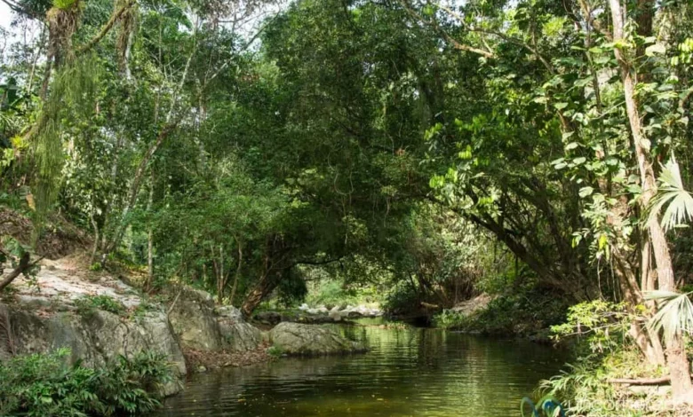
The journey begins with a transfer from Santa Marta to the village of Machete Pelao, the official trailhead. The initial stages of the trek involve a steep climb through farmland and secondary forests. This segment serves as a physical introduction to the region’s intense humidity and high temperatures. Hikers navigate a series of ascents and descents that lead into the Buritaca River valley, where the first of several communal campsites are located.

Phase Two: Entering Indigenous Territory
As the trail moves deeper into the Sierra Nevada, it crosses into the ancestral lands of the Kogi and Wiwa peoples. The landscape shifts into primary tropical rainforest. Hikers must frequently cross the Buritaca River, sometimes utilizing manual cable cars when water levels are dangerously high due to seasonal rains. Along this route, travelers pass traditional villages consisting of circular, thatched-roof huts (muecas), providing a glimpse into a way of life that has remained largely unchanged for centuries.

Phase Three: The Arrival at Teyuna
The final approach to the Lost City requires ascending 1,200 narrow, moss-covered stone steps. These steps lead to the main residential and ceremonial terraces. Reaching the summit at dawn is a primary goal for most expeditions, as the early morning light provides the clearest views of the mountain range and the architectural precision of the terraces. Indigenous guides often perform traditional cleansings or share oral histories at the site, emphasizing the spiritual connection between the "Elder Brothers" (the indigenous people) and the "Younger Brothers" (the rest of humanity).

Phase Four: The Return Journey
The return leg follows the same path back to Machete Pelao. While the route is familiar, the physical toll of the previous days and the potential for heavy afternoon downpours make the final 23 kilometers a significant test of endurance. The trek concludes with a return transfer to Santa Marta.

Logistical Requirements and Environmental Data
The Sierra Nevada de Santa Marta is the world’s highest coastal mountain range, rising from the Caribbean Sea to nearly 5,700 meters. The Lost City itself sits at an elevation of approximately 1,200 meters (3,900 feet).

Climate and Seasonality
The region experiences a tropical rainforest climate characterized by high humidity (often exceeding 90%) and average temperatures between 25°C and 30°C (77°F to 86°F).

- Dry Season (December to March): Generally considered the optimal time for trekking, with lower rainfall and clearer trails.
- Rainy Season (May to November): Features heavy afternoon downpours that can turn trails into deep mud and cause river levels to rise rapidly.
- Annual Closure: The trail is traditionally closed for the month of September. This closure is requested by the indigenous communities to allow for spiritual purification of the land and to facilitate environmental recovery and trail maintenance.
Physical and Health Considerations
The trek is classified as medium-high difficulty. While it does not require technical climbing skills, it demands high cardiovascular fitness. The combination of steep gradients and heat exhaustion is the primary challenge for most participants. Health risks include mosquito-borne illnesses such as Dengue fever, though malaria is less common at these altitudes. Trekkers are advised to use high-DEET repellents and maintain rigorous hydration.

Indigenous Stewardship and Official Responses
A defining characteristic of the Lost City Trek is the involvement of indigenous guides. Organizations such as G Adventures have partnered with local indigenous-led tour operators to ensure that tourism revenue directly benefits the mountain communities.

Indigenous leaders, often referred to as Mamos (spiritual elders), have expressed a complex relationship with the increasing influx of tourists. In various statements, representatives of the Wiwa and Kogi communities have emphasized that they view themselves as the guardians of the "Heart of the World." They permit tourism not merely for economic gain, but as an opportunity to educate the "Younger Brothers" on the importance of environmental conservation and the interconnectedness of nature.

The Colombian Institute of Anthropology and History (ICANH) maintains a permanent presence at the site to monitor the structural integrity of the terraces. Official responses to the growth of tourism have focused on sustainability. Current regulations limit the number of daily visitors to prevent over-tourism from eroding the ancient stone structures or disrupting the local ecology.

Broader Impact and Implications
The opening of the Lost City to international tourism has had profound socio-economic implications for the region. Historically, parts of the Sierra Nevada were hotspots for the cultivation of coca and were influenced by armed groups during Colombia’s internal conflict. The transition to a tourism-based economy has provided a legal and stable livelihood for many former coca farmers and indigenous families.

Economic Development
The trek supports a vast network of workers, including guides, cooks, mule drivers (who transport supplies to campsites), and lodge operators. This micro-economy has improved infrastructure in remote villages like Machete Pelao, though it has also brought challenges regarding waste management and the preservation of traditional values in the face of Western influence.

Cultural Preservation
The requirement for indigenous guides ensures that the history of Teyuna is told through the lens of those who consider it sacred. This prevents the "Disneyfication" of the site and reinforces the cultural identity of the Wiwa and Kogi peoples. However, there is an ongoing debate regarding how much of the "sacred" should be shared with outsiders and how to protect the privacy of indigenous villages located along the trail.

Environmental Conservation
The Sierra Nevada de Santa Marta is a UNESCO-recognized Biosphere Reserve and a haven for biodiversity, including numerous endemic bird species. The Lost City Trek serves as a case study for "regenerative tourism," where the presence of hikers and the oversight of tour operators help deter illegal logging and poaching. The September closure remains a critical policy for maintaining this balance, ensuring the jungle has time to reclaim its silence and the ecosystem can reset.

In conclusion, the hike to the Lost City is more than a physical endurance test; it is a journey through a living cultural landscape. As Colombia continues to grow as a global travel destination, the management of Ciudad Perdida will remain a pivotal example of how ancient heritage can be preserved through the collaboration of government agencies, international travel organizations, and indigenous guardians. For the trekker, the reward is not merely the view from the top terraces, but an immersion into a civilization that refused to be lost, choosing instead to wait for the world to learn how to respect its sacred ground.


