Discovering California’s Majestic Mountain Loop: A Six-Day Itinerary Through Yosemite, Kings Canyon, and Sequoia National Parks

The American West has long been defined by its dramatic topography, and few regions encapsulate this grandeur quite like California’s Sierra Nevada range. For travelers seeking a comprehensive immersion into high-alpine wilderness without the burden of exhaustive, cross-state transit, the "Majestic Mountain Loop" offers an optimal solution. Spanning approximately 200 miles of contiguous roadway, this circuit connects three of the nation’s most iconic protected areas—Yosemite, Kings Canyon, and Sequoia National Parks—into a seamless six-day itinerary that begins and ends in Fresno.

While traditional itineraries often require extensive backtracking or long-haul driving days between major metropolitan hubs like San Francisco and Los Angeles, a localized circuit based out of regional transit points introduces unprecedented efficiency. By flying directly into Fresno Yosemite International Airport, motorists can bypass hours of valley transit, accessing the Sierra foothills within an hour. This geographic advantage has transformed the 200-mile loop into one of the most accessible yet deeply rewarding road trips in the United States, appealing to multigenerational families, environmental tourists, and casual travelers alike.

Strategic Route Planning and Regional Logistics

A successful traversal of the Majestic Mountain Loop hinges on strategic base-camp selection. Rather than attempting to commute from distant urban centers, travel planners recommend dividing the six-day journey between two primary gateway communities: the Bass Lake/Oakhurst area near Yosemite’s southern entrance, and Visalia, situated centrally to the west of Sequoia and Kings Canyon.

The chronological flow of the trip is designed to minimize vehicular fatigue while maximizing exposure to distinct ecological zones. Day one initiates the circuit with a short drive northeast from Fresno to Bass Lake, a reservoir community located fifteen miles south of Yosemite National Park. Providing a serene counterpoint to the high-volume tourism of the Yosemite Valley floor, Bass Lake offers immediate recreational decompression, featuring aquatic activities and proximity to the historic Yosemite Mountain Sugar Pine Railroad.

Day two and three direct travelers into Yosemite National Park. Entering via Highway 41, visitors are advised to cross the park gates by early morning—ideally before 8:00 a.m.—to mitigate congestion on the valley floor. High-priority attractions during this phase include the Mist Trail, a three-to-seven-mile round-trip trek encompassing Vernal and Nevada Falls, as well as panoramic overlooks such as Glacier Point and Tunnel View. Geographically positioned at 7,200 feet, Glacier Point provides critical visual context, allowing visitors to observe the structural scale of Half Dome and the valley floor from a commanding elevation.

Transitioning South: Kings Canyon and the Great Western Divide

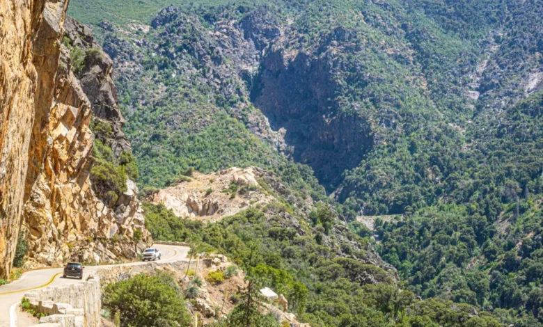
By day four, the itinerary shifts southward along the Sierra Nevada foothills toward Kings Canyon National Park, located approximately two hours from Bass Lake. Managed jointly with Sequoia National Park, Kings Canyon presents a stark geological contrast to Yosemite. Here, the landscape is defined by the Kings Canyon Scenic Byway, a dramatic roadway that descends 4,000 feet into one of North America’s deepest canyons.

The descent reveals the sheer verticality of the Sierra Nevada, culminating in Cedar Grove—a wide glacial meadow flanked by the turquoise waters of the South Fork Kings River. Visitors frequently explore the Grant Grove section, home to the General Grant tree, the third-largest giant sequoia on Earth. Following a full day of exploration within the canyon, travelers proceed southwest to Visalia, an agricultural hub functioning as the southern anchor of the loop. Boasting a robust culinary scene rooted in Central Valley agriculture, Visalia offers lodging and dining infrastructure at price points significantly lower than accommodations situated directly within park boundaries.

Day five is dedicated entirely to Sequoia National Park, accessed via the highway leading upward from Visalia. The primary focal point of this leg is the Giant Forest, which shelters the General Sherman tree—the world’s largest living organism by volume, containing an estimated 52,508 cubic feet of wood. Alongside General Sherman, the area features Moro Rock, a granite dome scaled via a 350-step staircase that yields 360-degree vistas across the Great Western Divide, and the Congress Trail, a flat, accessible loop winding through dense clusters of ancient sequoias.

Economic and Environmental Implications

The structured loop format addresses longstanding logistical challenges associated with National Park visitation in California, where overcrowding and parking deficits frequently impact visitor satisfaction. By dispersing tourism across secondary gateway communities such as Oakhurst, Bass Lake, and Visalia, the regional economy benefits from sustained hospitality revenue, while park infrastructure experiences a more regulated influx of visitors.

Furthermore, the utilization of regional transit systems—such as the Visalia Sequoia Shuttle, which operates seasonally to transport visitors directly from downtown hotels to the Giant Forest Museum—helps mitigate vehicular congestion within sensitive ecological zones. This multimodal approach aligns with broader federal conservation objectives aimed at reducing carbon emissions and parking strain within high-density national parks.

Optimal Timing and Preparation

According to regional tourism data, the optimal window for executing the Majestic Mountain Loop spans from late May through early October. While summer months experience peak visitor volume, the shoulder seasons of late September and October offer moderated temperatures, diminished crowds, and autumnal foliage changes. However, travelers must monitor weather patterns closely; high-elevation routes, including Glacier Point Road and the Kings Canyon Scenic Byway, remain subject to seasonal closures and snow delays until late spring.

Essential preparation for the journey includes the acquisition of the America the Beautiful National Parks Pass. Priced at $80, the pass covers standard entry fees for Yosemite, Sequoia, and Kings Canyon, offsetting individual park entrance fees within the first forty-eight hours of travel.

As travelers complete the circuit on day six—either returning to Fresno for departure or extending their journey toward coastal metropolitan centers like San Francisco—the itinerary leaves behind a blueprint for efficient, high-impact domestic travel. By balancing rigorous alpine exploration with accessible regional infrastructure, the Majestic Mountain Loop demonstrates how regional tourism can successfully accommodate high public interest while preserving the integrity of America’s protected wilderness.
Related posts: