
The Pakora Pass Trek: Navigating the High-Altitude Corridor Connecting Naltar and Ishkoman Valleys

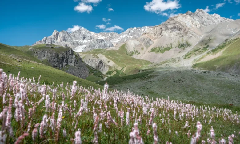
The Pakora Pass, frequently referred to by locals as the Naltar Pass, serves as a high-altitude natural artery linking the Naltar Valley of the Gilgit District to the Ishkoman Valley in the Ghizer District of Gilgit-Baltistan, Pakistan. For years, this route has remained a peripheral path favored by local shepherds and seasoned mountaineers, bypassing the heavily trafficked tourist circuits of the Karakoram Range. As interest in sustainable and off-the-beaten-path tourism in Northern Pakistan continues to rise, the Pakora Pass has emerged as a focal point for those seeking a balance of environmental preservation, cultural immersion, and challenging alpine terrain.
Geographical Context and Strategic Significance
The Gilgit-Baltistan region is home to three of the world’s major mountain ranges—the Himalayas, the Karakoram, and the Hindu Kush. While international expeditions and commercial trekking companies have long prioritized the K2 Basecamp and the Biafo-Hispar glacier traverses, the Naltar-to-Ishkoman route offers a different perspective on the region’s topography. The pass sits at a significant elevation, characterized by a transition from the lush, sub-alpine coniferous forests of Naltar to the rugged, glaciated terrain of the Ishkoman valley.
Geographically, the trek acts as a bridge between two distinct cultural and linguistic zones. The Naltar region is deeply influenced by the tourism infrastructure centered near the regional capital of Gilgit, while the Ishkoman Valley remains one of the most culturally insulated and hospitable corridors in the Ghizer District. The transit across the pass is more than a physical journey; it represents a historical link between pastoral communities that have utilized these high-altitude pastures, or "nallas," for seasonal grazing for centuries.
Chronology of the Three-Day Traverse
The trek is typically completed in three distinct stages, requiring moderate to high levels of physical fitness and familiarity with high-altitude navigation.
Day One: Ascent into the Alpine Pastures
The journey begins at the Naltar zero point, often facilitated by a vehicular approach to the Satrangi Lake region. From this starting point, the route tracks eastward along the river, navigating through meadows that serve as primary summer grazing grounds for regional livestock. Historical data on trail maintenance suggests that while maps may indicate bridge crossings, seasonal flooding frequently renders these structures unstable. Consequently, contemporary navigation relies on local knowledge, which often dictates staying on the eastern side of the river to avoid infrastructure hazards. The first stage concludes in the lower Shani region, a plateau that provides a base camp for the subsequent, more strenuous ascent.
Day Two: The Glacial Crossing
The second day represents the technical crux of the expedition. Hikers must navigate the ascent to the Pakora Pass proper. The terrain shifts from alpine meadows to rocky, barren scree slopes, eventually leading to a glaciated section. Experts note that glacier travel in this region is dynamic; the ice morphology changes annually due to shifts in climate patterns and precipitation. Travelers must exercise caution, as the route is not permanently marked. At the summit, the pass provides a panoramic vantage point featuring the Shani Peak and, under favorable weather conditions, the distant silhouette of Rakaposhi. The descent involves navigating the glacier’s periphery, a phase of the trek that requires specialized footwear and, according to local safety experts, the assistance of a trained guide to mitigate the risks associated with soft ice and hidden crevasses.
Day Three: The Descent into the Ishkoman Valley
The final phase of the trek descends through the Pakora Nala. This descent is characterized by a significant change in vegetation as the elevation drops into dense juniper forests. This area is noted for its ecological preservation, as the narrow, rugged nature of the paths prevents the use of pack animals for most of the descent. The route terminates at Pakora village, where the landscape opens into the wider Ishkoman valley.
Economic and Logistical Framework
For those planning to traverse the pass, logistics revolve around a combination of local service providers and independent preparation. The cost of engaging a professional guide—a recommended measure for those without extensive high-altitude experience—ranges upwards of 12,000 PKR per day, depending on the scope of services including logistics, gear, and language translation.
The role of the local guide is multifaceted. Beyond navigation, guides serve as intermediaries in cultural exchanges with nomadic shepherd communities. These interactions are a defining feature of the trek, offering insights into the transhumance practices that define the socio-economic life of Gilgit-Baltistan. For budget-conscious travelers, independent trekking is feasible, though it requires proficiency in using offline mapping tools such as OSMand, as cellular connectivity is nonexistent once the trek departs from the Naltar base area.
Impact of Sustainable Tourism
The increase in trekking activity in the Ghizer District has brought both economic benefits and environmental management challenges. The "Coyote Den" facility in Chatorkhand, situated near the trek’s end, reflects a growing trend toward providing infrastructure that supports long-distance trekkers while maintaining the aesthetic and cultural integrity of the region.
From an analytical perspective, the Pakora Pass route serves as a case study for "low-impact" tourism. Unlike the high-volume treks in the Karakoram, the Naltar-to-Ishkoman route relies on existing shepherd paths rather than constructed trails. This minimizes the carbon footprint and physical degradation of the alpine ecosystem. However, this also means that the responsibility for waste management and trail safety falls heavily on the individual traveler. The local administration and tourism boards emphasize the importance of "Leave No Trace" principles, as the delicate alpine flora—which carpets the region in summer—is highly susceptible to trampling and non-native waste.
Safety Considerations and Expert Recommendations
Mountain safety experts emphasize that the Pakora Pass should not be underestimated. While the pass is not as technically demanding as high-altitude climbing expeditions, the remoteness of the region means that emergency response times are significant.
- Environmental Preparedness: Travelers must account for rapid weather changes common in the Gilgit-Baltistan region. Hypothermia and altitude sickness are primary risks, necessitating proper acclimatization before attempting the pass.
- Local Communication: Maintaining communication with local hosts in Ishkoman or Naltar is a standard safety protocol. Providing an itinerary to local stakeholders ensures that if a party fails to arrive at the anticipated time, local search and rescue resources can be mobilized efficiently.
- Infrastructure Limitations: As noted by recent expeditions, infrastructure such as bridges and paths are subject to immediate alteration by natural elements. Reliance on outdated guidebooks is discouraged in favor of real-time consultations with local guides who possess knowledge of the current trail conditions.
Future Implications for Regional Development
The promotion of the Pakora Pass as a premier trekking destination aligns with the broader goals of the Gilgit-Baltistan Tourism Department to diversify the region’s offerings. By spreading the influx of visitors from the Karakoram Highway corridor to the side valleys of the Ghizer District, the region can distribute economic gains more equitably among rural communities.
The Pakora Pass remains a symbol of the untapped potential of Northern Pakistan’s wilderness. It offers a rare opportunity to experience a landscape that is largely unchanged by the pressures of mass tourism. As the world becomes increasingly connected, the value of such remote, silent, and ecologically intact environments will only continue to rise, placing a greater burden on the current generation of trekkers to protect the sanctity of the route for those who will follow in their footsteps. Through a combination of responsible tourism, local engagement, and rigorous safety standards, the Pakora Pass will continue to stand as one of the most compelling, albeit demanding, trekking experiences in the Himalayan-Karakoram region.