
Master of Malt Unveils Limited Edition Whisky Collection to Celebrate International Football Tournament
Master of Malt, the renowned online retailer and independent bottler, has launched an exclusive five-strong limited-edition whisky collection designed to coincide with this summer’s highly anticipated international football tournament. This curated selection features a diverse array of English, Scottish, and Irish whiskies, all sourced from Master of Malt’s own cask programme. The collection pays homage to the iconic tournaments that have left an indelible mark on generations of football supporters, with each bottle adorned with unique label artwork created by in-house designers Ben McKeown and Chris Gunter. These designs draw direct visual inspiration from the distinctive kits of the Italia ’90 and France ’98 World Cups, evoking a sense of nostalgia and sporting passion.
The limited nature of these releases is a key feature, with outturns ranging from a mere 66 bottles to a maximum of 350 bottles per expression. This scarcity underscores the collectibility of the range and appeals to both whisky aficionados and football enthusiasts looking for a unique way to commemorate the event. The strategic timing of this release taps into the heightened excitement surrounding major international sporting competitions, where fans often seek commemorative items to mark significant occasions.
A Confluence of Spirits and Sport: The Collection’s Genesis
The idea behind this collection stems from the powerful emotional connection between major sporting events and shared cultural experiences. International football tournaments, in particular, have a unique ability to unite nations and create lasting memories. Master of Malt’s initiative aims to capture this spirit by offering a tangible, sophisticated memento. By drawing from its extensive network of distilleries and its own cask maturation program, the company has been able to craft a range that is both diverse in its origin and consistent in its quality.
The choice to focus on English, Scottish, and Irish whiskies is significant. These nations have rich and distinct whisky-making traditions, and their national football teams have all had memorable moments in past international tournaments. The artwork, directly referencing iconic football kits, further reinforces the theme, transforming each bottle into a miniature piece of sporting memorabilia. The Italia ’90 and France ’98 World Cups were particularly significant, featuring memorable matches, emerging stars, and dramatic upsets that are still discussed by fans today.
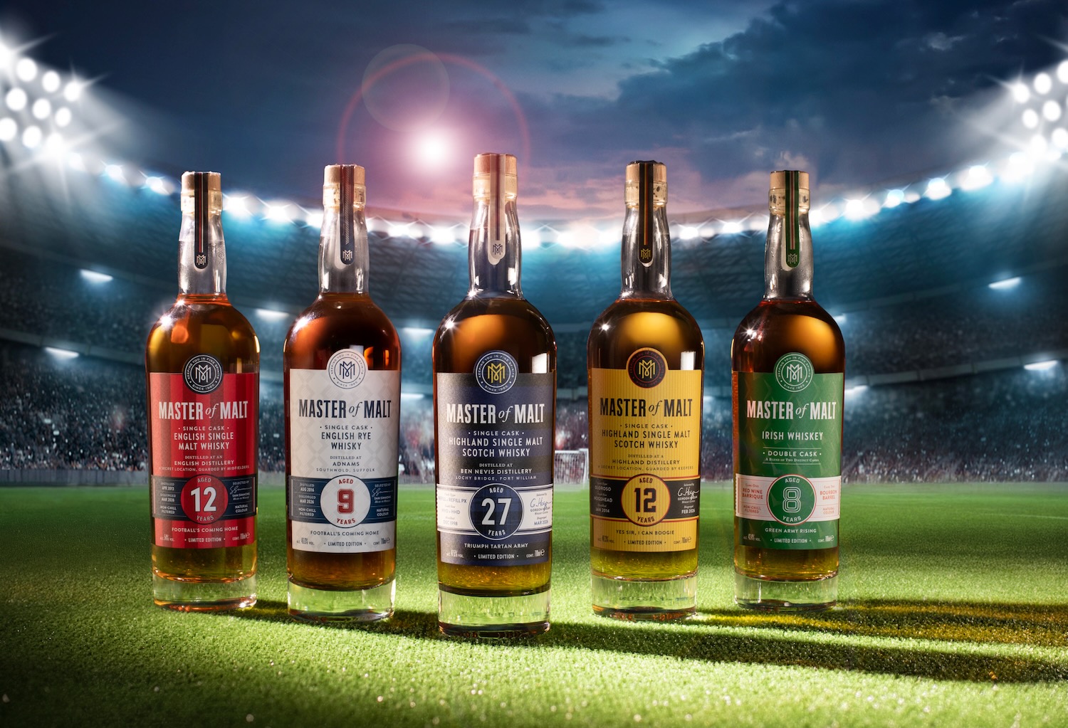
Deep Dive into the Collection: A Tantalizing Trio of Nations
The collection is meticulously crafted, offering a journey through different whisky styles and flavour profiles, each with a unique story to tell.
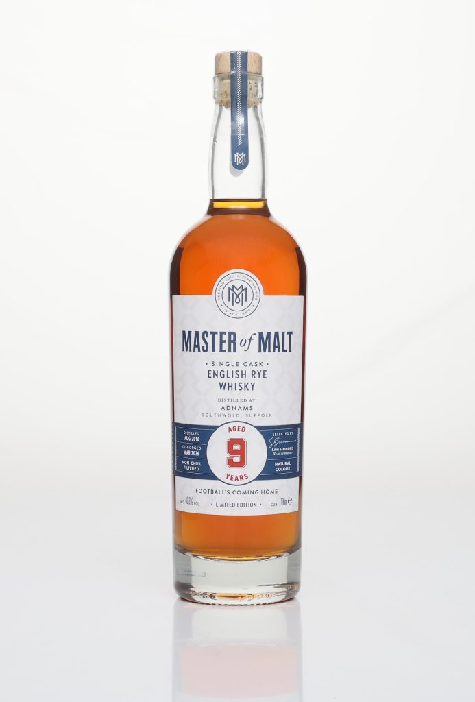
Adnams 9 Year Old – English Rye Whisky: A Taste of Suffolk’s Craftsmanship
The Adnams 9 Year Old English Rye Whisky is a distinguished single-cask offering from Adnams, a distillery based in Southwold, Suffolk. Adnams is recognised as one of England’s most accomplished craft distilleries, consistently setting a benchmark for quality in the English whisky category. This particular expression has been matured in a French oak wine cask, a choice that imparts a unique layer of complexity. Bottled at a robust 46.6% ABV, the whisky presents an inviting aroma and palate.
Tasting Notes: The nose and palate are described as leaning into notes of orange cream, ginger, Victoria sponge, and honey. This profile suggests a whisky that is both creamy and gently spiced, making it notably approachable even for those new to rye whisky. The French oak’s influence likely contributes to a softer, more integrated spice character compared to traditional American oak maturation.
Limited Availability: With an outturn of just 340 bottles, this expression highlights the exclusive nature of the collection, appealing to collectors and discerning drinkers alike. The rarity of high-quality English rye whisky further enhances its desirability.
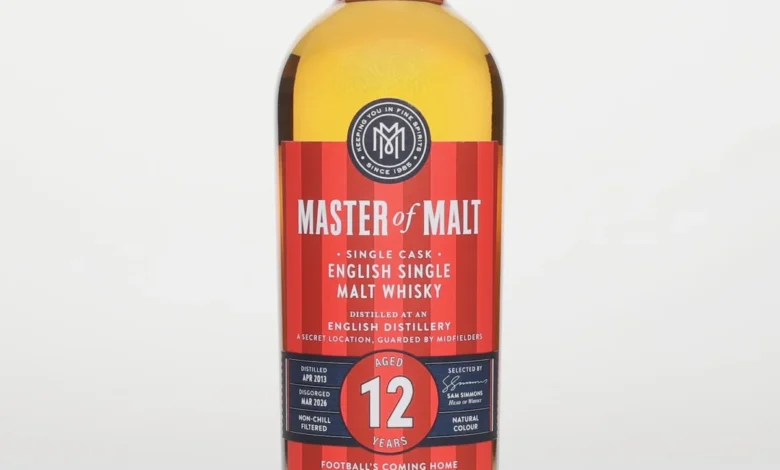
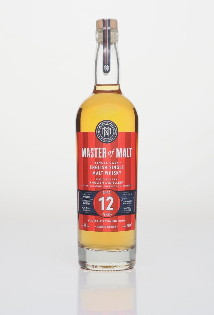
An English Distillery 12 Year Old – English Single Malt: A Bold Statement of Maturity
This 12 Year Old English Single Malt comes from an undisclosed English distillery, adding an element of intrigue. Matured in a bourbon cask, a classic choice for single malt maturation, and bottled at a potent 54% ABV, this whisky is presented in a cask-strength format. This signifies an intention to deliver a full-bodied and uncompromised flavour experience.
Tasting Notes: Described as bold and structured when neat, the whisky opens up generously with the addition of water. This reveals a more complex spectrum of flavours, including melon rind, molasses, ice cream, and waffles. The mention of "melon rind" suggests a refreshing counterpoint to the richer notes, while "ice cream" and "waffles" point towards a comforting, dessert-like sweetness. The whisky is presented as a "persuasive case for the seriousness of mature English single malt," suggesting that English distillers are now producing whiskies that can stand shoulder-to-shoulder with established Scotch and Irish counterparts.
Limited Availability: Limited to 240 bottles, this cask-strength offering is a testament to the growing reputation of English single malt whisky. The scarcity emphasizes the opportunity to experience a truly premium example of this emerging category.
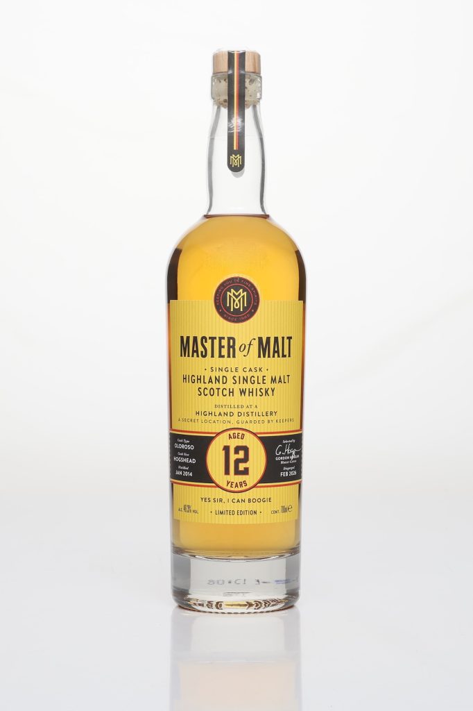
A Highland Distillery 12 Year Old – Highland Single Malt: Classic Sherry Influence
From the heart of Scotland’s whisky landscape, this 12 Year Old Highland Single Malt is matured in an Oloroso sherry cask, a classic combination that promises depth and richness. The whisky hails from an undisclosed Highland distillery and is bottled at 46.3% ABV. The Highland region is known for its diverse whisky styles, and this expression leans into the tradition of sherry cask maturation.
Tasting Notes: The nose is characterized as fruity and nutty, with a "friendly, sherried lift." This suggests an inviting aroma that balances sweetness with a subtle nuttiness. The palate is said to bring roasted nuts and sultanas, classic notes associated with Oloroso sherry, complemented by a "balancing thread of salt and sweetness." This interplay of flavours indicates a well-rounded and complex dram. The whisky is praised for being "beautifully composed and eminently drinkable," highlighting its balance and immediate appeal.
Limited Availability: With an outturn of 350 bottles, this Highland single malt represents the largest bottling within the collection, yet remains highly limited. It offers a more traditional yet refined Highland experience.
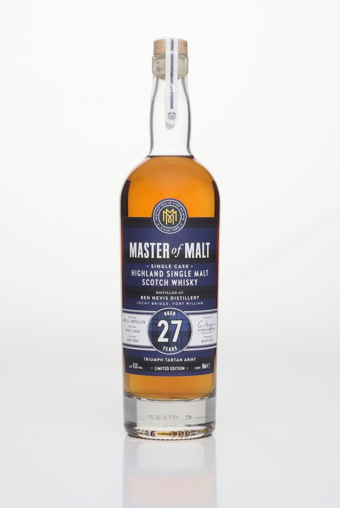
Ben Nevis 27 Year Old – Highland Single Malt: A Rare Gem of Age and History
The undisputed headline release of the collection, and indeed the rarest, is the Ben Nevis 27 Year Old Highland Single Malt. Distilled at the Ben Nevis Distillery in Fort William in December 1998, this bottling holds particular significance as it was distilled in the same month Scotland last qualified for a World Cup. This historical resonance adds a unique narrative layer to the whisky.
This single cask expression has undergone an extensive maturation process, spending its time in refill and refill PX hogsheads. The use of PX (Pedro Ximénez) hogsheads, known for their intense sweetness and dark fruit characteristics, suggests a rich and complex flavour profile. The whisky was disgorged in March 2026, marking its culmination after nearly three decades of aging. Bottled at 47.5% ABV, it presents a compelling profile.
Tasting Notes: The nose offers layered oak, spice, and herbal notes, indicating a mature whisky with significant oak influence but also herbaceous complexity. The palate transitions through tropical fruit, melon rind, and molasses, showcasing a rich and decadent character. The finish is described as having "graceful complexity," a hallmark of older Ben Nevis whiskies, which are increasingly sought after for their distinctive character and aging potential.
Limited Availability: With an exceptionally limited outturn of just 129 bottles, this Ben Nevis 27 Year Old is a true collector’s item. Its rarity, combined with its age and historical connection to Scottish football, makes it the crowning jewel of the Master of Malt collection.
Irish Whiskey 8 Year Old – Double Cask: A Blended Celebration of the Emerald Isle
Completing the collection is an 8 Year Old Irish Whiskey, a blend of two casks from an undisclosed Irish distillery. This expression showcases the versatility of Irish whiskey, combining a 13-year-old matured in a red wine barrique with an 8-year-old matured in a first-fill bourbon barrel. This double cask maturation is married and bottled at 43.4% ABV, aiming for a harmonious balance of influences.
Tasting Notes: The nose is described as fresh and fruity, hinting at vibrant notes. The palate delivers "fleshy sweetness" and a noticeable presence of oak and tannin, likely from the red wine barrique’s influence, balanced by the smoother notes from the bourbon barrel. The finish offers a lingering taste of grapes, melon, and vanilla custard, suggesting a sweet, creamy, and fruit-forward conclusion.
Limited Availability: This Irish Whiskey boasts the smallest outturn in the entire range, with only 66 bottles available. This extreme rarity makes it a highly sought-after expression, appealing to those who appreciate the nuanced blends of Irish whiskey and the thrill of owning something truly exceptional.
The Broader Impact: A Boost for Independent Bottlers and Niche Markets
The release of this limited-edition collection by Master of Malt has several implications. Firstly, it provides a significant platform for independent bottlers and smaller distilleries to showcase their products to a wider audience. By curating a themed collection, Master of Malt creates a narrative that appeals beyond just the individual whiskies, drawing in consumers who might not otherwise explore these specific expressions.
Secondly, it taps into the growing trend of consumers seeking unique and commemorative items associated with major events. The fusion of a global sporting spectacle with a premium consumable like whisky is a smart strategy that caters to a passionate and often affluent demographic. The success of such initiatives can encourage other retailers and producers to explore similar cross-promotional opportunities.
The emphasis on limited outturns also speaks to the growing demand for rare and collectible whiskies. As the global demand for aged and single-cask spirits continues to rise, bottlers are increasingly focusing on exclusivity to drive value and desirability. This collection aligns perfectly with that market trend.
Official Response and Availability
Master of Malt has stated that the entire "Master of Malt Independent Bottlings Football Special Edition" range is available exclusively on their website, masterofmalt.com. This direct-to-consumer approach allows for maximum control over the release and ensures that dedicated fans can access the collection. The limited nature of the bottlings means that enthusiasts are advised to act swiftly to secure their preferred expressions.
The collection represents more than just a series of whisky releases; it’s a carefully crafted narrative that bridges the worlds of sport and fine spirits. By evoking memories of iconic football tournaments through its art and by offering exceptional whiskies from diverse origins, Master of Malt has created a unique offering that is sure to resonate with collectors, connoisseurs, and football fans alike. The limited quantities ensure that each bottle holds a special place in the annals of both sporting memorabilia and whisky appreciation.


