Fractals in the Dirt: Unveiling the Geological and Ecological Significance of the Mancos Shale Across the American West

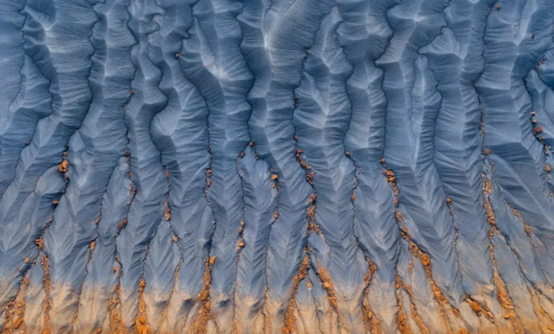
For millions of motorists traversing the American Southwest, the landscape presents itself as a monolithic canvas of towering red rock arches, wind-carved sandstone monuments, and jagged alpine peaks. Yet, beneath the tires of heavy commercial trucks and the gaze of transcontinental travelers lies a ubiquitous, unassuming geologic formation that quietly shapes the topography, ecology, and human infrastructure of the region. The Mancos Shale, a Late Cretaceous marine deposit spanning vast swaths of New Mexico, Arizona, Colorado, Wyoming, and Utah, represents one of the most expansive, least-appreciated geological units in North America. Though frequently dismissed as mere dust or treacherous mud, this ancient seabed tells a complex, multi-million-year story of climate transformation, inland oceans, and the ongoing evolutionary pressures shaping the modern American West.
Historical Context and Chronological Formation
To understand the Mancos Shale, geologists must look back approximately 90 million to 80 million years ago, during the Turonian through Campanian ages of the Late Cretaceous epoch. At this time, a massive warm, shallow body of water known as the Western Interior Seaway (or the Cretaceous Seaway) bisected the North American continent, stretching from the Arctic Ocean down to the Gulf of Mexico. This inland sea effectively split the continent into two landmasses: Laramidia to the west and Appalachia to the east.
Over millions of years, tectonic activity associated with the nascent Rocky Mountain orogeny uplifted adjacent lands, sending torrents of sediment eroded from rising highlands into the marine basin. Fine-grained silts and muds settled quietly on the seafloor, accumulating thousands of feet of sediment. When the seaway ultimately receded due to regional crustal uplift and sea-level regression, these compacted layers emerged as a massive geologic blanket.
Named by geologist Whitman Cross in 1899 after the town of Mancos, Colorado—where typical exposures are prominently displayed near Mesa Verde—the Mancos Shale formation now covers tens of thousands of square miles. Its lithology is predominantly friable, gray-to-blue-brown mudstone and shale, interspersed with thin layers of sandstone, limestone, and bentonite clay derived from ancient volcanic ash falls.
Geotechnical Properties and Environmental Challenges
The very composition that gives the Mancos Shale its characteristic appearance—fine clay minerals and marine salts—also renders it uniquely problematic for human infrastructure and highly sensitive to environmental forces. Because the shale is rich in expansive smectite clays, it undergoes drastic volumetric changes when exposed to moisture. During heavy precipitation events or agricultural irrigation, the dry, powdery earth swells rapidly into a sticky, impassable gumbo mud. Conversely, during dry spells, it contracts and fractures into intricate, geometric patterns resembling miniature badlands and geometric mudcracks.
Civil engineers and transportation departments across the American West view the Mancos Shale with a mixture of caution and dread. Roads, highways, and building foundations constructed over the formation are notoriously susceptible to structural shifting, buckling pavement, and slope failures. Landslides and rockfalls are frequent occurrences along corridors carved through Mancos terrain, requiring millions of dollars annually in road stabilization, drainage management, and geotechnical maintenance.
Furthermore, because the shale was deposited in an ancient marine environment, it contains high concentrations of soluble salts, selenium, and other minerals. When irrigation water or precipitation runs off Mancos-derived soils, it leaches these minerals into local watersheds, particularly the Colorado River basin. Elevated levels of salinity and selenium present severe challenges for regional water quality, agricultural productivity, and native aquatic species, prompting extensive federal and state remediation efforts.
Ecological Dynamics and Flora Adaptations
Despite its forbidding nature for human development, the Mancos Shale supports a specialized and resilient ecosystem. The soils derived from the formation are often fine-grained, alkaline, and nutrient-poor, creating harsh conditions that deter dense vegetation cover. However, these same factors have fostered high levels of botanical endemism.
Several rare and endangered plant species are strictly adapted to the chemistry and physical instability of Mancos-derived substrates. Plants such as the Mancos milkvetch (Astragalus humistratus var. oblongifolius) and various specialized buckwheat species have evolved physiological mechanisms to tolerate high selenium concentrations and shifting soils. These barren, badland-like expanses, often referred to as "shale barrens," serve as critical habitats for specialized insects, reptiles, and ground-nesting birds that thrive in open, sparsely vegetated terrain.
Hydrological and Agricultural Implications
The presence of the Mancos Shale heavily dictates hydrological management in the arid West. Because shale layers possess extremely low permeability, they frequently act as aquitards—confining layers that impede the vertical movement of groundwater. This characteristic influences regional aquifer systems, trapping water in overlying sandstone aquifers or forcing groundwater to discharge at the surface as saline springs.
Agricultural communities in western Colorado, eastern Utah, and northwestern New Mexico must carefully balance irrigation practices to avoid over-saturating Mancos soils. Excessive irrigation not only triggers destructive soil slumping and structural damage to farm infrastructure but also accelerates the leaching of subsurface salts into the Colorado River. Organizations such as the U.S. Bureau of Reclamation and local conservation districts have spent decades implementing salinity control programs, lining irrigation canals, and improving water-use efficiency to mitigate the downstream impacts of Mancos runoff on agricultural lands in Arizona, California, and Mexico.
Scientific Value and Paleontological Discoveries
Beyond its engineering and environmental challenges, the Mancos Shale is a treasure trove for paleontologists. The oxygen-poor, muddy conditions of the ancient Cretaceous seafloor created an exceptional environment for fossil preservation. While vertebrate fossils such as marine reptiles (mosasaurs and plesiosaurs) and occasional dinosaur remains washed in from nearby shores are documented, the formation is particularly renowned for its invertebrate fossil record.
Ammonites—extinct cephalopods with coiled, intricately chambered shells—are abundantly preserved throughout the Mancos Shale, alongside diverse species of clams, snails, and microscopic plankton shells known as foraminifera. These fossils provide invaluable data for biostratigraphy, allowing scientists to date rock layers with high precision and reconstruct ancient marine temperatures, chemistry, and sea-level fluctuations over a 10-million-year window.
Broader Impact and Public Perception
For the casual traveler crossing the vast open spaces of the Colorado Plateau, the Mancos Shale often registers merely as a scenic backdrop of gray-brown rolling hills or crumbling cliffs. Yet, its understated presence dictates the rhythm of life across five states. It forms the foundation of iconic landscapes like Mesa Verde National Park, where Ancestral Puebloans carved cliff dwellings into the more durable sandstone layers perched atop impermeable Mancos foundations.
As climate change alters precipitation patterns and increasing human populations place mounting demands on Western water resources, understanding the complex behaviors of foundational geologic formations like the Mancos Shale becomes increasingly critical. Far from being a mere geological footnote or a dusty obstacle on a desert highway, the Mancos Shale stands as a dynamic, deeply influential archive of Earth’s history—a sprawling subterranean architect shaping the topography, water quality, and ecological tapestry of the American West.