The Pakora Pass Trek from Naltar to Ishkoman Valley: A Comprehensive Guide to Northern Pakistan’s Untouched Wilderness

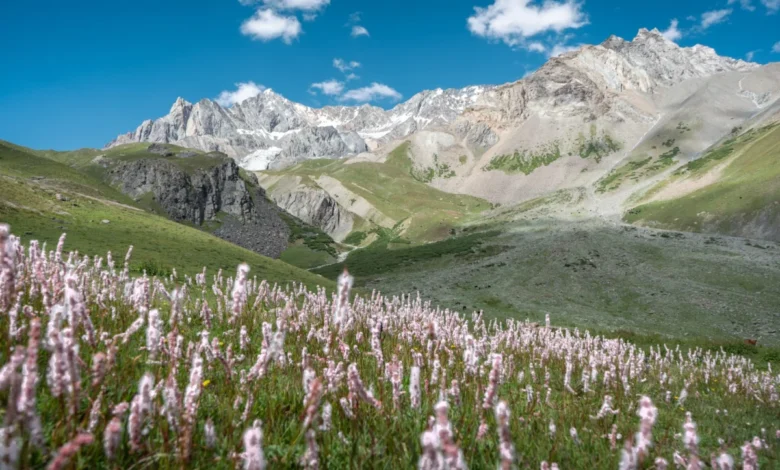
The Pakora Pass, frequently referred to by locals as the Naltar Pass, represents one of the most significant yet under-utilized high-altitude corridors in the Gilgit-Baltistan region of northern Pakistan. Connecting the lush, tourism-heavy Naltar Valley with the remote, culturally rich Ishkoman Valley, this three-day trek traverses some of the most ecologically diverse alpine terrain in the Karakoram range. Unlike the heavily trafficked routes toward K2 Basecamp or the Patundas Glacier, the Pakora Pass offers a unique, tranquil experience, characterized by minimal human interference and pristine, high-altitude biodiversity.
Geographical Context and Strategic Significance
Gilgit-Baltistan is home to three of the world’s major mountain ranges: the Himalayas, the Karakoram, and the Hindu Kush. The convergence of these systems has created a complex network of high-altitude passes that have served as trade routes and shepherd migration paths for centuries. The Pakora Pass sits at the intersection of these geographic features, acting as a natural gateway between the administrative hub of Gilgit and the rugged, isolated valleys of the Ghizer District.
The trail is increasingly viewed by regional authorities and conservationists as a vital link in a potential "Grand Route," which aims to connect Naltar, Ishkoman, Yasin, and Broghil, eventually extending into the Mastuj region of Chitral. This integration of trails could provide a sustainable economic boost to remote mountain communities, offering a viable alternative to the mass tourism currently concentrated in Hunza and Skardu.
Trekking Chronology and Route Analysis
The standard route for the Pakora Pass trek is typically completed in three days and two nights. Modern logistics for this trek begin at the Naltar zero point, where access is facilitated by 4×4 vehicles reaching the base of the Satrangi Lake.
Day One: Naltar to Lower Shani
The trek commences from the periphery of the Seven Colored Lake (Satrangi Lake). Hikers typically traverse the mountainside with the river situated to the west. While historical maps suggest multiple river crossings, recent hydrological reports and local guidance indicate that bridge infrastructure is subject to frequent seasonal damage. Consequently, most experienced guides advise remaining on the eastern bank, where the terrain is steeper but structurally more stable. The first day concludes at the Lower Shani encampment, a high-altitude meadow characterized by active pastoralism.
Day Two: The Ascent to Pakora Pass
The second day serves as the technical crux of the expedition. Hikers must choose between a higher route, which remains largely intact but demands strenuous climbing, and a lower route that has suffered degradation due to seismic activity and landslides. The ascent leads into alpine pastures, followed by a transition into the barren, high-altitude zone of the pass. The summit offers panoramic views of the Shani Peak and the surrounding glaciers. Crossing the glacier requires significant caution; as glacial movement is constant, the path is fluid, necessitating professional navigation and, in many cases, the use of specialized trekking equipment.
Day Three: The Descent into Pakora Nala
The final leg of the journey involves a significant descent into the Pakora Nala. This region is noted for its dense juniper forests and narrow, winding paths that have historically restricted the use of heavy pack animals, preserving the forest’s integrity. The route terminates in the Pakora village, which acts as a transition point into the wider Ishkoman Valley.
Economic and Logistical Framework
The cost of undertaking this expedition varies based on the level of support required. Professional local guides, who provide essential logistical oversight and act as cultural intermediaries, typically charge approximately 12,000 PKR per day. This rate covers route navigation and emergency coordination. For travelers on a limited budget, local shepherd communities occasionally provide guiding services for lower rates, though this requires a high degree of self-sufficiency and knowledge of the local Urdu dialect.
Infrastructure in the Ishkoman Valley, specifically in the village of Chatorkhand, has seen recent upgrades. Facilities such as the Coyote Den Ishkoman have established a standard for eco-conscious lodging, providing essential amenities that support the growing demand for sustainable adventure tourism. These establishments are increasingly acting as information centers for safety protocols, including tracking hiker movements to ensure search and rescue readiness.
Safety Protocols and Environmental Considerations
Trekking in the high altitudes of the Karakoram is not without risk. The primary hazards include altitude sickness, unpredictable weather patterns, and the instability of glacial crossings. According to safety experts in the region, the following measures are essential:
- Guided Navigation: Given the lack of clear, maintained trails in the high-pass areas, the presence of an experienced local guide is strongly recommended to navigate shifting glacial debris and landslide zones.
- Communication: Satellite-based communication or local cellular networks should be accounted for, though connectivity is sporadic. Registering travel plans with local guesthouses serves as an informal check-in system.
- Environmental Stewardship: As an untouched, pristine environment, the Pakora Pass is sensitive to waste accumulation. Leave-no-trace principles are strictly advised, particularly regarding the disposal of organic waste near water sources.
- Hydrological Safety: While mountain springs ("chashma") provide clean water, hikers should verify water safety with local shepherds to avoid areas impacted by livestock or sediment runoff.
Broader Impact and Implications
The development of the Pakora Pass as a recognized trekking corridor carries significant implications for the region. By diversifying the tourism portfolio of Gilgit-Baltistan, the trek alleviates the environmental pressure currently exerted on more popular, high-density areas. Furthermore, the integration of local communities—specifically the shepherd populations of Naltar and the residents of Ishkoman—into the tourism value chain ensures that the economic benefits of trekking are distributed equitably.
However, the expansion of such routes must be managed with a focus on conservation. The juniper forests and alpine meadows of the Pakora Nala are critical habitats for local fauna and are susceptible to degradation if tourism volume is not strictly regulated. Stakeholders in the Gilgit-Baltistan tourism sector have emphasized the need for a "low-impact, high-value" model for this corridor, prioritizing small, organized groups over mass tourism.
Conclusion: A Sustainable Future for Adventure Tourism
The Pakora Pass is more than just a route; it is a testament to the untapped potential of the northern mountain ranges of Pakistan. For the seasoned trekker, it offers a rare opportunity to engage with a landscape that remains largely untouched by the modern world. For the region, it represents a path toward a more diversified and resilient tourism economy. As the infrastructure in the Ishkoman and Naltar valleys continues to mature, the Pakora Pass is poised to become a staple of responsible, high-altitude exploration, provided that environmental and safety standards remain at the forefront of its development.
Travelers are encouraged to engage with local experts and utilize established, reputable guide services to ensure that their presence contributes positively to the regions they traverse. Whether one is drawn by the allure of the high-altitude glaciers or the profound hospitality of the Ishkoman valley, the Pakora Pass remains a hallmark of the rugged, untamed beauty of northern Pakistan.